El Nido, Los Angeles County, California
El Nido, California | |
|---|---|
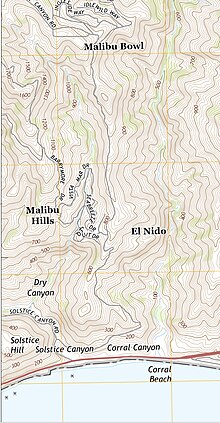
 Corral Canyon is in the bottom left, El Nido is the development in the canyon closer to the beach | |
 | |
| Coordinates: 34°02′37″N 118°44′21″W / 34.04361°N 118.73917°W | |
| Country | |
| State | |
| County | |
| Elevation | 244 m (801 ft) |
| GNIS feature ID | 1660598[1] |
El Nido (Spanish for "The Nest") is a residential neighborhood in Corral Canyon in unincorporated Los Angeles County, California, United States. The community, originally developed in the 1920s,[2] is in the Santa Monica Mountains along the northern border of Malibu.[3] There are two developments in Corral Canyon, El Nido is the lower of the two.[4] The other was known as Newell in 1958[5] and has more recently been known as Malibu Bowl.[6][2] The El Nido houses look down on Solstice Canyon, the so-called "Mystery Silo" (used by TRW and JPL scientists in the mid-20th-century for testing of satellite equipment away from sources of electromagnetic interference), and a long-disused tract owned by the DWP that is prone to landslides.[7] There are 5.2 homes per acre in El Nido.[8]
The 2007 Corral Canyon fire destroyed 53 homes including a number in El Nido.[9]
The Malibu El Nido is not to be confused with the Redondo Beach El Nido, along the former Hawthorne–El Nido Line of the Pacific Electric railway.

References
[edit]- ^ "El Nido". Geographic Names Information System. United States Geological Survey, United States Department of the Interior.
- ^ a b "Mountain Development Plan OK'd". The Los Angeles Times. November 3, 1980. p. 29. Retrieved November 7, 2023.
- ^ California Department of Transportation (2005). State Highway Map 2005 (Map). Retrieved June 6, 2019 – via David Rumsey Historical Map Collection.
- ^ "Malibu residents help one another as they struggle to get their lives back — or just get into town". Los Angeles Times. November 18, 2018. Retrieved November 7, 2023.
- ^ "The Los Angeles Times 03 Dec 1958, page 1". Newspapers.com. Retrieved November 7, 2023.
- ^ "Malibu, again". The Los Angeles Times. November 25, 2007. p. 23. Retrieved November 7, 2023.
- ^ "Malibu residents want DWP to shore up landslide area". The Los Angeles Times. June 14, 2005. p. 7. Retrieved November 7, 2023.
- ^ "Corral Canyon". The Los Angeles Times. May 16, 1982. p. 613. Retrieved November 7, 2023.
- ^ "Before the worst happens". Topanga Messenger. December 17, 2009. p. 27. Retrieved November 7, 2023.

