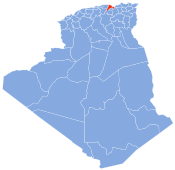
El Kseur District
Appearance
This article needs additional citations for verification. (August 2021) |
El Kseur District | |
|---|---|
 | |
| Country | |
| Province | Béjaïa Province |
| Time zone | UTC+1 (CET) |
El Kseur District (القصر منطقة ايل) is a district of Béjaïa Province, Algeria, and the region of Kabylie.[1] Its capital is located in the town of El Kseur. The district abuts the Mediterranean Sea to the north.
The dïstrict includes the three communes
References
[edit]36°41′04″N 4°51′08″E / 36.684389°N 4.852095°E

