Eilean Mullagrach
Appearance
 | |
| Location | |
|---|---|
| Coordinates | 58°2′50.17″N 5°27′39.82″W / 58.0472694°N 5.4610611°W |
| Physical geography | |
| Area | 39 hectares (0.15 sq mi)[1] |
| Highest elevation | 46 metres (151 ft)[2] |
| Administration | |
| Council area | Highland |
| Country | Scotland |
| Sovereign state | United Kingdom |
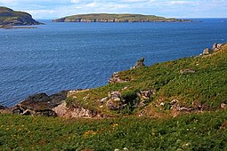
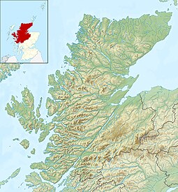
Eilean Mullagrach is an island in the Summer Isles of Scotland.[3] It is located in Highland council area, in the northwestern part of the country, 800 km northwest of the United Kingdom capital London. It is the most northerly of the Summer Isles.[4] Its area is 39 hectares[1][Note 1] and the maximum elevation is 46 metres (151 ft).[2]
In 2024 the island, which has a small cabin and landing point with ladders for a small boat, was put up for sale for "offers over £500,000".[1]
Bird life on the island includes kittiwakes, bonxies, shags and fulmars.[1]
Notes
[edit]- ^ The Gazetteer for Scotland states 75 ha[4] and "Rick Livingstone's Tables" has 29 ha[5] but the BBC's estimate corresponds more closely to an approximation from Ordnance Survey maps. Haswell-Smith does not include it in his tables of islands greater in area than 40 ha.[6]
Gallery
[edit]-
The landing point
-
The cabin
-
Grey seal near the island
-
Eilean Mullagrach from Isle Ristol
References
[edit]- ^ a b c d "Island for sale: Limited viewing, sturdy footwear essential.". BBC News. Retrieved 13 June 2024.
- ^ a b Ordnance Survey. OS Maps Online (Map). 1:25,000. Leisure.
- ^ "Eilean Mullagrach". Retrieved 18 April 2017.
- ^ a b "Mullagrach, Eilean". Gazetteer for Scotland. Retrieved 15 December 2018.
- ^ "Rick Livingstone's Tables of the Islands of Scotland" (PDF). Argyll Yacht Charters. Retrieved 24 February 2019.
- ^ Haswell-Smith, Hamish (2004). The Scottish Islands. Edinburgh: Canongate. ISBN 978-1-84195-454-7.
Wikimedia Commons has media related to Eilean Mullagrach.


