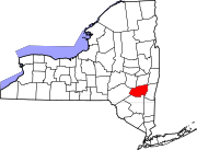
East Jewett, New York
Appearance
East Jewett, New York | |
|---|---|
| Coordinates: 42°14′06″N 74°08′44″W / 42.23500°N 74.14556°W | |
| Country | United States |
| State | New York |
| County | Greene |
| Elevation | 1,965 ft (599 m) |
| Time zone | UTC-5 (Eastern (EST)) |
| • Summer (DST) | UTC-4 (EDT) |
| ZIP code | 12424 |
| Area code(s) | 518 & 838 |
| GNIS feature ID | 949141[1] |
East Jewett is a hamlet in Greene County, New York, United States. The community is 2.8 miles (4.5 km) north of Tannersville. East Jewett had a post office from January 31, 1829, until early 2000; it still has its own ZIP code, 12424.[2][3]
Climate
[edit]| Climate data for East Jewett, New York, 1991–2020 normals, extremes 1985-2020: 1991ft (607m) | |||||||||||||
|---|---|---|---|---|---|---|---|---|---|---|---|---|---|
| Month | Jan | Feb | Mar | Apr | May | Jun | Jul | Aug | Sep | Oct | Nov | Dec | Year |
| Record high °F (°C) | 64 (18) |
75 (24) |
83 (28) |
89 (32) |
90 (32) |
91 (33) |
94 (34) |
95 (35) |
94 (34) |
83 (28) |
75 (24) |
68 (20) |
95 (35) |
| Mean maximum °F (°C) | 55 (13) |
55 (13) |
64 (18) |
76 (24) |
84 (29) |
86 (30) |
88 (31) |
86 (30) |
84 (29) |
77 (25) |
68 (20) |
56 (13) |
90 (32) |
| Mean daily maximum °F (°C) | 30.6 (−0.8) |
33.1 (0.6) |
40.2 (4.6) |
52.9 (11.6) |
64.8 (18.2) |
73.0 (22.8) |
77.2 (25.1) |
75.6 (24.2) |
68.9 (20.5) |
57.3 (14.1) |
45.6 (7.6) |
35.0 (1.7) |
54.5 (12.5) |
| Daily mean °F (°C) | 20.9 (−6.2) |
22.4 (−5.3) |
29.4 (−1.4) |
41.3 (5.2) |
52.6 (11.4) |
61.1 (16.2) |
65.3 (18.5) |
63.6 (17.6) |
56.9 (13.8) |
46.4 (8.0) |
36.2 (2.3) |
26.6 (−3.0) |
43.6 (6.4) |
| Mean daily minimum °F (°C) | 11.2 (−11.6) |
11.8 (−11.2) |
18.5 (−7.5) |
29.7 (−1.3) |
40.3 (4.6) |
49.2 (9.6) |
53.5 (11.9) |
51.6 (10.9) |
44.9 (7.2) |
35.4 (1.9) |
26.8 (−2.9) |
18.2 (−7.7) |
32.6 (0.3) |
| Mean minimum °F (°C) | −10 (−23) |
−9 (−23) |
−3 (−19) |
16 (−9) |
26 (−3) |
34 (1) |
42 (6) |
39 (4) |
29 (−2) |
22 (−6) |
10 (−12) |
−2 (−19) |
−14 (−26) |
| Record low °F (°C) | −27 (−33) |
−24 (−31) |
−19 (−28) |
2 (−17) |
21 (−6) |
28 (−2) |
35 (2) |
32 (0) |
16 (−9) |
16 (−9) |
−11 (−24) |
−23 (−31) |
−27 (−33) |
| Average precipitation inches (mm) | 4.41 (112) |
3.10 (79) |
4.83 (123) |
4.84 (123) |
4.00 (102) |
4.60 (117) |
4.60 (117) |
5.06 (129) |
5.27 (134) |
6.04 (153) |
4.76 (121) |
4.54 (115) |
56.05 (1,425) |
| Average snowfall inches (cm) | 20.90 (53.1) |
18.40 (46.7) |
18.40 (46.7) |
6.30 (16.0) |
0.20 (0.51) |
0.00 (0.00) |
0.00 (0.00) |
0.00 (0.00) |
0.00 (0.00) |
2.10 (5.3) |
6.10 (15.5) |
22.10 (56.1) |
94.5 (239.91) |
| Source 1: NOAA[4] | |||||||||||||
| Source 2: XMACIS (temp records & monthly max/mins)[5] | |||||||||||||
References
[edit]- ^ "East Jewett". Geographic Names Information System. United States Geological Survey, United States Department of the Interior.
- ^ United States Postal Service. "USPS - Look Up a ZIP Code". Retrieved August 29, 2017.
- ^ "Postmaster Finder - Post Offices by ZIP Code". United States Postal Service. Archived from the original on October 17, 2020. Retrieved August 29, 2017.
- ^ "East Jewett, New York 1991-2020 Monthly Normals". Retrieved October 24, 2023.
- ^ "xmACIS". National Oceanic and Atmospheric Administration. Retrieved October 24, 2023.


