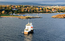
Dyna Lighthouse
Appearance
 | |
 | |
| Location | Oslo Norway |
|---|---|
| Coordinates | 59°53′42″N 10°41′18″E / 59.894875°N 10.688419°E |
| Tower | |
| Constructed | 1875 |
| Construction | wooden house |
| Automated | 1972[1] |
| Height | 12.5 metres (41 ft) |
| Shape | lantern in one corner of the keeper's house |
| Markings | white lighthouse and lantern, red lantern roof |
| Operator | Dyna Fyr[3] |
| Heritage | cultural property |
| Light | |
| Focal height | 6 metres (20 ft) |
| Intensity | 3,830 cd |
| Range | white: 9 nautical miles (17 km; 10 mi) red: 9 nautical miles (17 km; 10 mi) green: 8 nautical miles (15 km; 9.2 mi)[2] |
| Characteristic | Oc (3) WRG 8s. |
Dyna Lighthouse (Norwegian: Dyna fyr) is a coastal lighthouse on a reef south of Bygdøy, in Oslofjord, Oslo, Norway. It was established in 1875 and automated in 1956.[4][5]

In 1992 the lighthouse was renovated as a private banqueting facility, available for parties of 20-40 persons from Easter to Christmas.[6]
See also
[edit]References
[edit]- ^ Dyna Lighthouse Norsk Fyrhistorisk Forening
- ^ leuchtturmseiten.de
- ^ Rowlett, Russ. "Lighthouses of Norway: Oslo Area (Akershus and Oslo)". The Lighthouse Directory. University of North Carolina at Chapel Hill. Retrieved 3 March 2016.
- ^ Godal, Anne Marit (ed.). "Dyna fyr". Store norske leksikon (in Norwegian). Norsk nettleksikon. Retrieved 15 January 2012.
- ^ Arstal, Aksel; Just, Carl, eds. (1966) [1938]. "Dyna fyr". Oslo byleksikon (in Norwegian) (2 ed.). Oslo: Aschehoug.
- ^ "Lighthouses of Norway: Oslo Area (Akershus and Oslo)".
External links
[edit]- Site of the restaurant (in Norwegian)
 Media related to Dyna fyr at Wikimedia Commons
- Norsk Fyrhistorisk Forening (in Norwegian)
