Dronfield Urban District
Appearance
| Dronfield | |
|---|---|
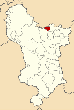
 Dronfield Urban District shown within Derbyshire in 1970. | |
| Area | |
| • 1911 | 1,045 acres (4.23 km2) |
| • 1961 | 3,452 acres (13.97 km2) |
| Population | |
| • 1911 | 3,943 |
| • 1961 | 11,303 |
| History | |
| • Created | 1894 |
| • Abolished | 1974 |
| • Succeeded by | North East Derbyshire |
| Status | Urban District |
| Government | Dronfield Urban District Council |
| • HQ | Dronfield |
Dronfield was an Urban District in Derbyshire, England from 1894 to 1974.[1][2] It was created under the Local Government Act 1894.
It was enlarged in 1935 when parts of the civil parishes of Coal Aston, Dronfield Woodhouse and Unstone were transferred to the district.
The district was abolished in 1974 under the Local Government Act 1972 and combined with Chesterfield Rural District (except the civil parish of Brimington) and Clay Cross Urban District to form the new North East Derbyshire district.
References
[edit]- ^ Great Britain Historical GIS / University of Portsmouth, Dronfield Urban District. Retrieved 2016-03-10.
- ^ F A Youngs Jr., Guide to the Local Administrative Units of England, Vol II: Northern England, London, 1991
53°18′09″N 1°27′59″W / 53.3024°N 1.4664°W
