Dro, Trentino
Appearance
Dro | |
|---|---|
| Comune di Dro | |
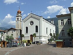
 Dro in Trentino - church | |
| Coordinates: 45°57′40″N 10°54′40″E / 45.96111°N 10.91111°E | |
| Country | Italy |
| Region | Trentino-Alto Adige/Südtirol |
| Province | Trentino (TN) |
| Frazioni | Ceniga, Pietramurata |
| Government | |
| • Mayor | Claudio Mimiola |
| Area | |
• Total | 27 km2 (10 sq mi) |
| Elevation | 123 m (404 ft) |
| Population (31 August 2021)[2] | |
• Total | 5,047 |
| • Density | 190/km2 (480/sq mi) |
| Demonym | Droati or droensi |
| Time zone | UTC+1 (CET) |
| • Summer (DST) | UTC+2 (CEST) |
| Postal code | 38074 |
| Dialing code | 0464 |
| Patron saint | Sant'Antonio (Dro), Santi Pietro e Paolo (Ceniga), Santa Lucia (Pietramurata) |
| Website | Official website |
Dro (Dró in local dialect) is a town and comune in Trentino in the northern Italian region of Trentino-Alto Adige/Südtirol. It sits in the deep Sarca river valley, and as of the 2021 census Dro had a population of 5,047. Dro is divided in two frazioni, Pietramurata and Ceniga.[3]
References
[edit]- ^ "Superficie di Comuni Province e Regioni italiane al 9 ottobre 2011". Italian National Institute of Statistics. Retrieved 16 March 2019.
- ^ "Popolazione Residente al 1° Gennaio 2018". Italian National Institute of Statistics. Retrieved 16 March 2019.
- ^ Gemeindestatut auf Italienisch (PDF; 155 kB), retrieved on May 11, 2017.


