Donalsonville Historic District
Appearance
Donalsonville Historic District | |
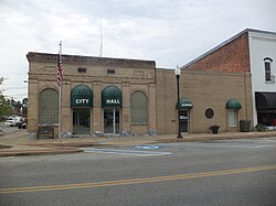
 Donalsonville City Hall on W. 2nd St. | |
| Location | Roughly bounded by the Seaboard RR line, W. Third St., and Morris and S. Tennille Aves., Donalsonville, Georgia |
|---|---|
| Coordinates | 31°02′33″N 84°52′57″W / 31.0425°N 84.8825°W |
| Area | 55 acres (22 ha) |
| Built | 1889 |
| Architect | William J.J. Chase and others |
| Architectural style | Beaux Arts, Early Commercial |
| NRHP reference No. | 02000190[1] |
| Added to NRHP | March 20, 2002 |
The Donalsonville Historic District in Donalsonville, Georgia is a 55-acre (22 ha) historic district that was listed on the National Register of Historic Places in 2002.[1]
It includes 48 contributing buildings and seven other contributing structures.
It includes the Seminole County Courthouse, which is separately listed on the National Register.[2]
References
[edit]- ^ a b "National Register Information System". National Register of Historic Places. National Park Service. July 9, 2010.
- ^ Steven Moffson and Paul Forgey (January 15, 2002). "National Register of Historic Places Inventory/Nomination: Donalsonville Historic District". National Park Service. Retrieved March 7, 2017. with 27 photos
Categories:
- Historic districts on the National Register of Historic Places in Georgia (U.S. state)
- Beaux-Arts architecture in Georgia (U.S. state)
- Buildings and structures completed in 1889
- National Register of Historic Places in Seminole County, Georgia
- Buildings designated early commercial in the National Register of Historic Places
- Georgia (U.S. state) Registered Historic Place stubs


