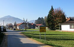
Dobriša Vas
Appearance
Dobriša Vas | |
|---|---|
 | |
| Coordinates: 46°14′24.98″N 15°10′33.94″E / 46.2402722°N 15.1760944°E | |
| Country | |
| Traditional region | Styria |
| Statistical region | Savinja |
| Municipality | Žalec |
| Area | |
• Total | 1.29 km2 (0.50 sq mi) |
| Elevation | 249.5 m (818.6 ft) |
| Population (2002) | |
• Total | 421 |
| [1] | |
Dobriša Vas (pronounced [dɔˈbɾiːʃa ˈʋaːs]; Slovene: Dobriša vas) is a settlement in the Municipality of Žalec in east-central Slovenia. It lies on the left bank of the Savinja River southeast of the town of Žalec. The area is part of the traditional region of Styria. The municipality is now included in the Savinja Statistical Region.[2]
References
[edit]External links
[edit] Media related to Dobriša Vas at Wikimedia Commons
- Dobriša Vas on Geopedia


