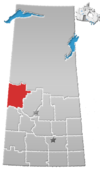
Division No. 17, Saskatchewan
Division No. 17 | |
|---|---|
| Country | Canada |
| Province | Saskatchewan |
| Area | |
| • Total | 22,457.10 km2 (8,670.73 sq mi) |
| As of 2016 | |
| Population (2016) | |
| • Total | 47,900 |
| • Density | 2.1/km2 (5.5/sq mi) |
Division No. 17 is one of eighteen census divisions in the province of Saskatchewan, Canada, as defined by Statistics Canada. It is located in the west-northwest part of the province, bordering Alberta. The most populous community in this division is the interprovincial city of Lloydminster. Another important population centre is the town of Meadow Lake.
Demographics
[edit]In the 2021 Census of Population conducted by Statistics Canada, Division No. 17 had a population of 47,834 living in 17,565 of its 23,104 total private dwellings, a change of -0.1% from its 2016 population of 47,900. With a land area of 22,222.67 km2 (8,580.22 sq mi), it had a population density of 2.2/km2 (5.6/sq mi) in 2021.[1]
Census subdivisions
[edit]The following census subdivisions (municipalities or municipal equivalents) are located within Saskatchewan's Division No. 17.
Cities
[edit]Towns
[edit]Villages
[edit]Resort villages
[edit]Rural municipalities
[edit]Indian reserves
[edit]- Big Island Lake Cree Nation
- Eagles Lake 165C
- Flying Dust First Nation 105
- Makaoo 120
- Makwa Lake 129
- Makwa Lake 129A
- Makwa Lake 129B
- Makwa Lake 129C
- Meadow Lake 105A
- Min-A-He-Quo-Sis 116C
- Ministikwan 161
- Ministikwan 161A
- Moosomin 112B
- Saulteaux 159
- Seekaskootch 119
- Thunderchild First Nation 115B
- Thunderchild First Nation 115C
- Thunderchild First Nation 115D
- Waterhen 130
See also
[edit]References
[edit]- ^ "Population and dwelling counts: Canada and census divisions". Statistics Canada. 9 February 2022. Retrieved 2 April 2022.
- ^ Statistics Canada. 2002 2001 Community Profiles. Archived 2005-12-22 at the Wayback Machine Released June 27, 2002. Last modified: 2005-11-30. Statistics Canada Catalogue no. 93F0053XIE. Page accessed January 5, 2007
- Division No. 17, Saskatchewan[permanent dead link] Statistics Canada
53°05′14″N 109°17′34″W / 53.08722°N 109.29278°W


