Digges Cove


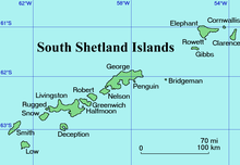
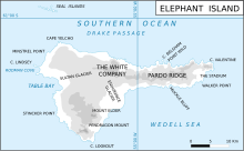
Digges Cove (Bulgarian: залив Дигс, romanized: zaliv Digges, IPA: ['zaliv 'digs]) is the 1.77 km wide cove indenting for 860 m the north coast of Elephant Island in the South Shetland Islands, Antarctica southeast of Eratosthenes Point. It was formed as a result of the retreat of Snellius Glacier in the late 20th century. The area was visited by early 19th century sealers.[1]
The feature is named after Leonard Digges (c. 1515–1559), a British mathematician and surveyor, inventor of the theodolite; in association with other names in the area deriving from the early development or use of geodetic instruments and methods.
Location
[edit]Digges Cove is centred at 61°06′07″S 55°02′56″W / 61.10194°S 55.04889°W,[2] which is 18 km east-southeast of Cape Yelcho and 10.14 km west of Point Wild. British mapping of the area in 1822,1972 and 2009.
Maps
[edit]- Chart of South Shetland including Coronation Island, &c. from the exploration of the sloop Dove in the years 1821 and 1822 by George Powell Commander of the same. Scale ca. 1:200000. London: Laurie, 1822
- Elephant Island: From a survey by the Joint Services Expedition, December 1970. Scale 1:132000 topographic map. Royal Geographical Society (UK), 1972
- British Antarctic Territory. Scale 1:200000 topographic map. DOS 610 Series, Sheet W 61 54. Directorate of Overseas Surveys, Tolworth, UK, 1972
- South Shetland Islands: Elephant, Clarence and Gibbs Islands. Scale 1:220000 topographic map. UK Antarctic Place-names Committee, 2009
- Antarctic Digital Database (ADD). Scale 1:250000 topographic map of Antarctica. Scientific Committee on Antarctic Research (SCAR). Since 1993, regularly upgraded and updated
Notes
[edit]- ^ A. Gurney. Below the Convergence: Voyages Toward Antarctica, 1699-1839. New York: Penguin Books, 1998. 315 pp.
- ^ Bulgarian Antarctic Gazetteer. Antarctic Place-names Commission
References
[edit]- Bulgarian Antarctic Gazetteer. Antarctic Place-names Commission. (details in Bulgarian, basic data in English)
External links
[edit]- Digges Cove. Adjusted Copernix satellite image
This article includes information from the Antarctic Place-names Commission of Bulgaria which is used with permission.
