Dewaitha
Dewaitha
Daudpur | |
|---|---|
Village | |
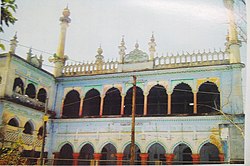
 Purani Masjid of Dewaitha built in 1605 by Raja Daud Khan, founder of Dewaitha, | |
| Coordinates: 25°21′50″N 83°38′38″E / 25.364°N 83.644°E | |
| Country | |
| State | Uttar Pradesh |
| District | Ghazipur |
| Established | 1605 |
| Founded by | Raja Daud Khan |
| Government | |
| • Type | Panchayati Raj (India) |
| • Body | Gram Pradhan |
| Area | |
| • Total | 442.22 ha (1,092.75 acres) |
| Elevation | 70 m (230 ft) |
| Population (2011) | |
| • Total | 7,104 |
| • Density | 1,600/km2 (4,200/sq mi) |
| Demonym | Kamsari |
| Languages | |
| • Official | Bhojpuri, Hindi |
| Time zone | UTC+5:30 (IST) |
| PIN | 232326[1] |
| Telephone code | 05497 |
| Vehicle registration | UP 61 |
Dewaitha is a village in Dildarnagar Kamsar, Ghazipur, India, on the banks of the Karmanasa River. The village had a population of 7,104 as of the 2011 Census of India and a land area of 1,043 acres.[2][3][4][5][when?] Most of the people living in the village are Kamsar Pathan. The village falls under the Zamania tehsil of Ghazipur district.
History
[edit]Dewaitha village was established by Raja Sarkar Diwan Daud Khan a descendents of Narhar Khan in year 1605 who was great grand son of Narhar Khan. His descendents are known as Kamsar Pathans. His cousin was Raja Sarkar Diwan Kuttul Khan who established a large Jagir estate also known as Kamsar Jagir and build a fort at Seorai during later years of Akbar's rule, his jagir was spread over 52 villages. But later he was killed in a dispute with a zamindar of Reotipur name as Man singh rai. Daud Khan after taking revenge of his cousin's death became noble man of his time and got power of the region, and established ,Daudpur estate after his name. It was a estate which had many villages with its capital being Dewaitha. He also built a soldier settelment at Village name Daudpur (after his name) and a Fort at dewaitha, which is converted into ruins. [6]
His legacy of Zamindarana and jagirdarana continued in his family with corporation. During the region of a Yad Ali Khan , sixth generation grandson of Daud Khan, the area gained a lot of power. Those were the last days of Nawab of Ghazipur. Yad Ali's family is now known as Athoghar. The village had their riayat and kot. The people here took a active role in rebellion of 1857, under , Kunwar singh of Darbahanga. After independence the village became a panchayat. Wasil Khan was the first pradhan of Dewaitha, under whom the first primary school was build. Some parts of the Daudpur region was under Vizianagaram princely state during late British raj. Although now Daudpur is not popular in common language of the people.[5][7][8][6]
Demographics
[edit]As of the 2011 Census of India, the total area of the village was 442.22 hectares. The village had a total population of 7,104 and 917 households.[2][5][4]
References
[edit]- ^ "Pin Code: Dewaitha, Ghazipur, Uttar Pradesh, India, Pincode.net.in". PINCode Search, Post Office Details, All India Post Office Data Pincode.net.in. Retrieved 3 September 2018.
- ^ a b "Pincode of Dewaitha village in Zamania tehsil, Ghazipur District". Archived from the original on 10 December 2011.
- ^ "Bhulekh". Archived from the original on 6 May 2016.
- ^ a b "2011 census of India". Archived from the original on 10 May 2006.
- ^ a b c "Panchyati Raj, Ghazipur". Archived from the original on 28 December 2019.
- ^ a b Ansari, Saiyad Hasan (1986). "Evolution and Spatial organisation of Clan settlements in Middle ganga valley. A book by Ansari Sayed Hasaan (1986)".
- ^ "Ghazipur Gazeteer".
- ^ Gottschalk, Peter (2013). Sikarwar Rajputs history and conversion to Islam. Oup USA. ISBN 978-0-19-539301-9.

