Denguélé District
Appearance
Denguélé District
District du Denguélé | |
|---|---|
 | |
| Country | |
| Established | 2011 |
| Capital | Odienné |
| Area | |
• Total | 20,900 km2 (8,100 sq mi) |
| Population (2021 census)[2] | |
• Total | 436,015 |
| • Density | 21/km2 (54/sq mi) |
| HDI (2022) | 0.440[3] low · 13th of 14 |
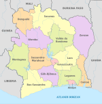
Denguélé District (French: district du Denguélé, [distʁikt dy dɛnɡele]) is one of fourteen administrative districts of Ivory Coast. The district is located in the northwest corner of the country. The capital of the district is Odienné.
Creation
[edit]Denguélé District was created in a 2011 administrative reorganisation of the subdivisions of Ivory Coast.[4] The territory of the district was composed of the former Denguélé Region.[1]
Administrative divisions
[edit]Denguélé District is currently subdivided into two regions and the following departments:
- Folon Region (region seat in Minignan)
- Kabadougou Region (region seat also in Odienné)
Population
[edit]According to the 2021 census, Denguélé District has a population of 436,015,[2] making it the second least populated district of the country behind Yamoussoukro Autonomous District.
References
[edit]- ^ a b "Districts of Côte d'Ivoire (Ivory Coast)". Statoids.com. Retrieved 24 June 2015.
- ^ a b Citypopulation.de Population of the districts of Ivory Coast
- ^ "Sub-national HDI - Area Database - Global Data Lab". hdi.globaldatalab.org. Retrieved 2024-09-24.
- ^ Décret n° 2011-263 du 28 septembre 2011 portant organisation du territoire national en Districts et en Régions.

