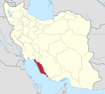
Deh Kohneh, Tangestan
Appearance
Deh Kohneh
Persian: ده كهنه | |
|---|---|
Former Village | |
| Coordinates: 28°55′05″N 51°08′48″E / 28.91806°N 51.14667°E[1] | |
| Country | Iran |
| Province | Bushehr |
| County | Tangestan |
| District | Central |
| Rural District | Baghak |
| Population (2006)[2] | |
• Total | 230 |
| Time zone | UTC+3:30 (IRST) |
Deh Kohneh (Persian: ده كهنه)[3] was a village in Baghak Rural District of the Central District of Tangestan County, Bushehr province, Iran.
Demographics
[edit]Population
[edit]At the time of the 2006 National Census, the village's population was 230 in 51 households.[2]
History
[edit]In 2010, the villages of Ali Shams ol Din, Bagh-e Salem-e Jonubi, Bagh-e Salem-e Shomali, Deh-e Now, Deh Kohneh, Jovey, Mal Barik, Rameh Char, Shamshiri, and Tokhmari merged to form the village of Baghak-e Jonubi.[4]
See also
[edit]References
[edit]- ^ OpenStreetMap contributors (28 August 2024). "Deh Kohneh, Tangestan County" (Map). openstreetmap.org (OpenStreetMap) (in Persian). Retrieved 28 August 2024.
- ^ a b Census of the Islamic Republic of Iran, 1385 (2006): Bushehr Province. amar.org.ir (Report) (in Persian). The Statistical Center of Iran. Archived from the original (Excel) on 20 September 2011. Retrieved 25 September 2022.
- ^ Deh Kohneh can be found at GEOnet Names Server, at this link, by opening the Advanced Search box, entering "6028383" in the "Unique Feature Id" form, and clicking on "Search Database".
- ^ Rahimi, Mohammad Reza (11 November 2018). "Ten changes in the map of country divisions of four provinces". farsnews.ir (in Persian). Ministry of Interior, Political and Defense Commission. Archived from the original on 16 June 2023. Retrieved 16 June 2023 – via Fars Media Corporation.


