Dasi, Tianjin
Dasi Town
大寺镇 | |
|---|---|
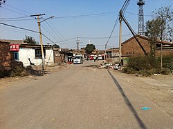
 Beikou Village on the northeast of the town, 2011 | |
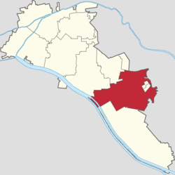
 Location of Dasi Town within Xiqing District | |
| Coordinates: 39°01′07″N 117°14′03″E / 39.01861°N 117.23417°E | |
| Country | |
| Municipality | Tianjin |
| District | Xiqing |
| Village-level Divisions | 10 communities 15 villages |
| Area | |
• Total | 69.73 km2 (26.92 sq mi) |
| Elevation | 4 m (13 ft) |
| Population (2010) | |
• Total | 113,290 |
| • Density | 1,600/km2 (4,200/sq mi) |
| Time zone | UTC+8 (CST) |
| Postal code | 300385 |
| Area code | 022 |
Dasi Town (simplified Chinese: 大寺镇; traditional Chinese: 大寺鎮; pinyin: Dàsì Zhèn) a town situated in the eastern part of Xiqing District, Tianjin, China. It shares a border with Meijiang and Taihulu Subdistricts to its north, Shuanggang Town and Haitang Subdistrict to its east, Xinzhuang and Balitai Towns to its southeast, Wangwengzhuang Town to its south, Jingwu Town and Liqizhuang Subdistrict to its west, and Jinmenhu Subdistrict to its northwest. The town also contains two subdistricts within: Chilongnan and Chilongbei Subdistricts. The population of this town is 113,290 as of 2010.[1]
The town's name "Dasi" (Chinese: 大寺; lit. 'Great Temple') is referring to Yongxi Temple that was constructed here during the Song dynasty.[2]
Geography
[edit]Dasi Town is situated on the northern bank of Duliujian River. Tianjin-Hebei Expressway passes through the town.[2]
History
[edit]| Time | Status | Belong to |
|---|---|---|
| Song and Jin dynasties | Qianning County | |
| Yuan dynasty | Jinghai County | |
| Ming and Qing dynasties | Jinghai County, Hejian Prefecture | |
| 1923–1950 | 1st District, Jinghai County | |
| 1950–1953 | 1st District, Tianjin County | |
| 1953–1957 | Dasi Township
Da Lubeikou Township |
Jinxijiao District, Tianjin |
| 1957–1958 | Da Nanhe Township | Jinghai County |
| 1958–1959 | Da Lubeikou Township | Xijiao District, Tianjin |
| 1959–1963 | Da Lubeikou Management Area
Dasi Management Area | |
| 1963–1964 | Da Lubeikou People's Commune | |
| 1964–1968 | Dasi People's Commune | |
| 1968–1980 | Dasi Revolutionary Committee | |
| 1980–1983 | Dasi People's Commune | |
| 1983–1992 | Dasi Township | |
| 1992–1995 | Xiqing District, Tianjin | |
| 1995–present | Dasi Town |
Administrative divisions
[edit]As of the year 2022, Dasi Town is divided into 25 subdivisions, more specifically 10 residential communities and 15 villages. They are listed as follows:[3]
| Subdivision Names | Name Transliterations | Type |
|---|---|---|
| 泉集里 | Quanji Li | Community |
| 龙居花园 | Longju Huayuan | Community |
| 福特纳湾 | Futena Wan | Community |
| 博文苑 | Bowen Yuan | Community |
| 远洋万和城 | Yuanyang Wanhe Cheng | Community |
| 洛卡小镇 | Luoka Xiaozhen | Community |
| 金谊花园 | Jinyi Huayuan | Community |
| 龙顺园 | Longshun Yuan | Community |
| 金友花园 | Jinyou Huayuan | Community |
| 金瀚园 | Jinhan Yuan | Community |
| 梅江康城 | Meijiang Kangcheng | Community |
| 大寺 | Dasi | Village |
| 王村 | Wang Cun | Village |
| 芦北口 | Lubeikou | Village |
| 青凝候 | Qingninghou | Village |
| 王庄子村 | Wang Zhuangzi Cun | Village |
| 石庄子村 | Shi Zhuangzi Cun | Village |
| 李庄子村 | Li Zhuangzi Cun | Village |
| 南口 | Nankou | Village |
| 北口 | Beikou | Village |
| 贾庄子 | Jia Zhuangzi | Village |
| 大任庄 | Da Renzhuang | Village |
| 周庄子 | Zhou Zhuangzi | Village |
| 倪黄庄 | Niehuang Zhuang | Village |
| 张道口 | Zhang Daokou | Village |
| 门道口 | Men Daokou | Village |
See also
[edit]References
[edit]- ^ "China: Tiānjīn Municipal Province (Districts and Townships) – Population Statistics, Charts and Map". www.citypopulation.de. Retrieved 2023-04-01.
- ^ a b c Zhonghua Renmin Gongheguo zheng qu da dian. Tianjin juan (Di 1 ban ed.). Beijing. 2020. ISBN 978-7-5087-6215-9. OCLC 1351675957.
{{cite book}}: CS1 maint: location missing publisher (link) - ^ "2022年统计用区划代码和城乡划分代码" [2022 Statistical Division Codes and Urban-rural Differentiation Codes]. www.stats.gov.cn (in Chinese). Archived from the original on 2023-03-28.


