Darvahi Rural District
Appearance
Darvahi Rural District
Persian: دهستان درواهي | |
|---|---|
| Coordinates: 29°22′43″N 51°04′37″E / 29.37861°N 51.07694°E[1] | |
| Country | Iran |
| Province | Bushehr |
| County | Dashtestan |
| District | Ab Pakhsh |
| Capital | Cham Darvahi |
| Population (2016)[2] | |
• Total | 3,211 |
| Time zone | UTC+3:30 (IRST) |
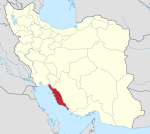
Darvahi Rural District (Persian: دهستان درواهي) is in Ab Pakhsh District of Dashtestan County, Bushehr province, Iran.[3] Its capital is the village of Cham Darvahi.[4]
Demographics
[edit]Population
[edit]At the time of the 2006 National Census, the rural district's population (as a part of Shabankareh District) was 4,546 in 937 households.[5] There were 3,056 inhabitants in 736 households at the following census of 2011,[6] by which time the rural district had been separated from the district in the formation of Ab Pakhsh District.[3] The 2016 census measured the population of the rural district as 3,211 in 931 households. The most populous of its eight villages was Chahar Borj, with 1,294 people.[2]
See also
[edit]References
[edit]- ^ OpenStreetMap contributors (25 August 2024). "Darvahi Rural District (Dashtestan County)" (Map). openstreetmap.org (OpenStreetMap) (in Persian). Retrieved 25 August 2024.
- ^ a b Census of the Islamic Republic of Iran, 1395 (2016): Bushehr Province. amar.org.ir (Report) (in Persian). The Statistical Center of Iran. Archived from the original (Excel) on 3 August 2017. Retrieved 19 December 2022.
- ^ a b Ahmadinejad, Mahmud (c. 2021) [Approval 7 May 1388]. Approval letter regarding reforms and divisional changes in Bushehr province. rc.majlis.ir (Report) (in Persian). Ministry of the Interior, Council of Ministers. Notification 99602/T43153 AH. Archived from the original on 26 August 2021. Retrieved 14 November 2023 – via Islamic Council Research Center.
- ^ Mousavi, Mirhossein (c. 2023) [Approved 18 May 1366]. Creation and formation of eight rural districts including villages, farms and places in Dashtestan County under Bushehr province. lamtakam.com (Report) (in Persian). Ministry of the Interior, Council of Ministers. Proposal 11813.1.5.53. Archived from the original on 1 December 2023. Retrieved 24 April 2024 – via Lam ta Kam.
- ^ Census of the Islamic Republic of Iran, 1385 (2006): Bushehr Province. amar.org.ir (Report) (in Persian). The Statistical Center of Iran. Archived from the original (Excel) on 20 September 2011. Retrieved 25 September 2022.
- ^ Census of the Islamic Republic of Iran, 1390 (2011): Bushehr Province. irandataportal.syr.edu (Report) (in Persian). The Statistical Center of Iran. Archived from the original (Excel) on 3 April 2023. Retrieved 19 December 2022 – via Iran Data Portal, Syracuse University.


