Dębowa Łęka
Dębowa Łęka | |
|---|---|
Village | |
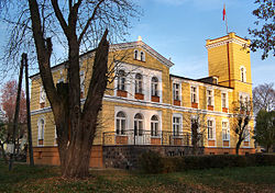
 Brodowski Palace in Dębowa Łęka | |
| Coordinates: 51°49′N 16°23′E / 51.817°N 16.383°E | |
| Country | |
| Voivodeship | Lubusz |
| County | Wschowa |
| Gmina | Wschowa |
| Time zone | UTC+1 (CET) |
| • Summer (DST) | UTC+2 (CEST) |
| Vehicle registration | FWS |
| Climate | Dfb |
| National road | |
Dębowa Łęka ([dɛmˈbɔva ˈwɛnka]) is a village in the administrative district of Gmina Wschowa, within Wschowa County, Lubusz Voivodeship, in western Poland.[1] It lies approximately 7 kilometres (4 mi) east of Wschowa and 62 km (39 mi) east of Zielona Góra. It is part of the historic region of Greater Poland.
History
[edit]
Dębowa Łęka was a private village of Polish nobility, administratively located in the Wschowa County in the Poznań Voivodeship in the Greater Poland Province of the Kingdom of Poland.[2] It was the seat of the Dębołęcki family of Prawdzic coat of arms.[3] In the 16th century it passed to the Ossowski family.[3]
It was annexed by Prussia in the Second Partition of Poland in 1793. Following the successful Greater Poland uprising of 1806, it was regained by Poles and included within the short-lived Duchy of Warsaw, and after the duchy's dissolution it was re-annexed by Prussia in 1815, officially under the Germanized name Geyersdorf. From 1871 it was also part of Germany. During World War II, it was the first settlement of pre-war Germany to be occupied by enemy forces, in conjunction with the Raid on Fraustadt (Wschowa) on 2 September 1939; Polish forces withdrew a few days later after the situation became untenable. After Germany's defeat in the war, in 1945, the village became again part of Poland and its historic[3] name Dębowa Łęka was restored.
Sights
[edit]Landmarks of Dębowa Łęka are the Gothic Saint Jadwiga church and the Brodowski Palace.
References
[edit]- ^ "Central Statistical Office (GUS) – TERYT (National Register of Territorial Land Apportionment Journal)" (in Polish). 2008-06-01.
- ^ Atlas historyczny Polski. Wielkopolska w drugiej połowie XVI wieku. Część I. Mapy, plany (in Polish). Warszawa: Instytut Historii Polskiej Akademii Nauk. 2017. p. 1a.
- ^ a b c Słownik geograficzny Królestwa Polskiego i innych krajów słowiańskich, Tom II (in Polish). Warszawa. 1881. p. 25.
{{cite book}}: CS1 maint: location missing publisher (link)


