Cueva del Guácharo National Park
| Cueva del Guácharo National Park | |
|---|---|
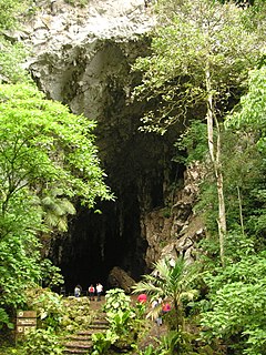
 Cave mouth | |
| Location | Monagas, Venezuela |
| Nearest city | Caripe |
| Coordinates | 10°12′00″N 63°38′23″W / 10.19989°N 63.63968°W |
| Area | 627 km² |
| Established | May 27, 1975 |
| Governing body | INPARQUES |
The Guácharo Cave National Park (Spanish: Parque Nacional Cueva del Guácharo) is located 12 km (7.5 mi) from the town of Caripe, Monagas, Venezuela. It has as its centerpiece a large limestone cave.
The cave was visited in 1799 by Alexander von Humboldt, who realised that the thousands of oilbirds (guácharos in Spanish; scientific name Steatornis caripensis) which live in the cave belonged to a species unknown to science. Humboldt named the frugivorous, nocturnal species after the town of Caripe.[1]
The cave
[edit]
The cave is a limestone cavern over 10 km (6.2 mi) long, with a number of large chambers and spectacular rock formations. The temperature inside the cave generally remains near 19 °C (66 °F) and the humidity at 100%.
Guácharo bird
[edit]
Oilbirds are fruit-eating birds that live within the first section of the cave; they leave at night in search of food. The Spanish name guácharo is onomatopoeic, and comes from an old Castilian word for one who shrieks or cries, because of their characteristic sound. They are brown with black and white spots, have a long tail and bristles around their beak. They measure around 48 cm (19 in) in length, including the tail. The guácharos produce an organic layer in the cave called guano, formed by excrement and vomited seeds, which provide the basic nutrients for the cave's ecosystem.
The most important daily event in the park occurs in the evening, as dusk falls, when the birds exit the cave in great flocks, in search of food. Visitors are able to view the birds leaving the cave.
Conservation
[edit]The cave was designated as Venezuela's first National Monument in 1949.
The National Park was created in 1975 to conserve the cave and the forest ecosystem where the oilbirds feed. The altitude of the national park is 900–2,340 m (2,950–7,680 ft). There are 367 species of bird in the national park, which has been designated an Important Bird Area (IBA). Although the oilbird is not an endangered species, several other resident birds fall into this category, for example the Venezuelan flowerpiercer (Diglossa venezuelensis) and the Venezuelan sylph. The national park is part of Cordillera de Caripe Alliance for Zero Extinction (AZE) site, along with another IBA, the Zona Protectora Macizo Montañoso del Turimiquire.[2]
Humboldt Museum
[edit]Near to the cave entrance is the Humboldt Museum.[note 1] It offers information about the cave, the national park, the oilbird (guácharo), and Alexander von Humboldt.
Notes
[edit]- ^ The Natural History Museum of Berlin, in Germany, has been popularly known for 60 years as the "Humboldt Museum" (from 1949 to 2009). This other Museum in Venezuela has nothing to do with the German museum located in Berlin.
References
[edit]- ^
- (in French) Le voyage aux régions equinoxiales du Nouveau Continent, fait en 1799-1804, Alexandre de Humboldt, Aimé Bonpland (Paris, 1807, etc.);
- (in English) Personal Narrative of Travels to the Equinoctial Regions of the New Continent During the Years 1799-1804 (London, 1814, etc.);
- (in German) Die Reise in die Äquinoktial-Gegenden des Neuen Continents in den Jahren 1799, 1800, 1801, 1802, 1803 und 1804, Alexander von Humboldt, Aimé Bonpland (Vienna, 1827, etc.)
- ^ BirdLife International (2015). ["Archived copy". Archived from the original on 2007-07-10. Retrieved 2014-04-01.
{{cite web}}: CS1 maint: archived copy as title (link)/datazone/sitefactsheet.php?id=14938 Important Bird Areas factsheet: Parque Nacional El Guácharo (part of Cordillera de Caripe AZE)]. Downloaded from "Archived copy". Archived from the original on 2007-07-10. Retrieved 2014-04-01.{{cite web}}: CS1 maint: archived copy as title (link) on 25/08/2015

