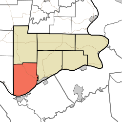
Craig Township, Switzerland County, Indiana
Appearance
Craig Township | |
|---|---|
 The Venoge Farmhouse, a historic site in the township | |
 Location in Switzerland County | |
| Coordinates: 38°44′48″N 85°08′53″W / 38.74667°N 85.14806°W | |
| Country | |
| State | |
| County | Switzerland |
| Government | |
| • Type | Indiana township |
| Area | |
• Total | 39.56 sq mi (102.5 km2) |
| • Land | 39.26 sq mi (101.7 km2) |
| • Water | 0.3 sq mi (0.8 km2) 0.76% |
| Elevation | 574 ft (175 m) |
| Population (2020) | |
• Total | 766 |
| • Density | 19/sq mi (7.5/km2) |
| ZIP codes | 47011, 47043, 47250 |
| GNIS feature ID | 453249 |
Craig Township is one of six townships in Switzerland County, Indiana, United States. As of the 2020 census, its population was 766 and it contained 393 housing units.[1]
| Census | Pop. | Note | %± |
|---|---|---|---|
| 1890 | 1,980 | — | |
| 1900 | 1,931 | −2.5% | |
| 1910 | 1,466 | −24.1% | |
| 1920 | 1,475 | 0.6% | |
| 1930 | 1,340 | −9.2% | |
| 1940 | 1,187 | −11.4% | |
| 1950 | 1,017 | −14.3% | |
| 1960 | 831 | −18.3% | |
| 1970 | 709 | −14.7% | |
| 1980 | 761 | 7.3% | |
| 1990 | 695 | −8.7% | |
| 2000 | 777 | 11.8% | |
| 2010 | 900 | 15.8% | |
| 2020 | 766 | −14.9% | |
| Source: US Decennial Census[2] | |||
History
[edit]Craig Township has the name of George Craig, a pioneer settler and afterward state legislator.[3]
The Thiebaud Farmstead, Venoge Farmstead, and Thomas T. Wright House are listed on the National Register of Historic Places.[4]
Geography
[edit]According to the 2010 census, the township has a total area of 39.56 square miles (102.5 km2), of which 39.26 square miles (101.7 km2) (or 99.24%) is land and 0.3 square miles (0.78 km2) (or 0.76%) is water.[5]
Unincorporated towns
[edit]- Braytown at 38°43′50″N 85°09′31″W / 38.730617°N 85.158564°W
- Five Points at 38°44′48″N 85°10′30″W / 38.746728°N 85.174953°W
- Lamb at 38°41′31″N 85°11′17″W / 38.692007°N 85.188009°W
- Long Run at 38°45′11″N 85°07′04″W / 38.753117°N 85.117729°W
(This list is based on USGS data and may include former settlements.)
Adjacent townships
[edit]- Pleasant Township (north)
- Jefferson Township (northeast)
- Milton Township, Jefferson County (west)
Cemeteries
[edit]The township contains these two cemeteries: McKay and Old Bethel.
Major highways
[edit]Airports and landing strips
[edit]- Robinson Airport
School districts
[edit]- Switzerland County School Corporation
Political districts
[edit]- Indiana's 9th congressional district
- State House District 68
- State Senate District 45
References
[edit]- United States Census Bureau 2008 TIGER/Line Shapefiles
- United States Board on Geographic Names (GNIS)
- IndianaMap
- ^ "Explore Census Data". data.census.gov. Retrieved April 12, 2024.
- ^ "Township Census Counts: STATS Indiana".
- ^ Cottman, George Streibe (1916). Indiana Magazine of History. p. 153.
- ^ "National Register Information System". National Register of Historic Places. National Park Service. July 9, 2010.
- ^ "Population, Housing Units, Area, and Density: 2010 - County -- County Subdivision and Place -- 2010 Census Summary File 1". United States Census. Archived from the original on February 12, 2020. Retrieved May 10, 2013.

