Cowessess 73
Appearance
Cowessess 73 | |
|---|---|
| Cowessess Indian Reserve No. 73 | |
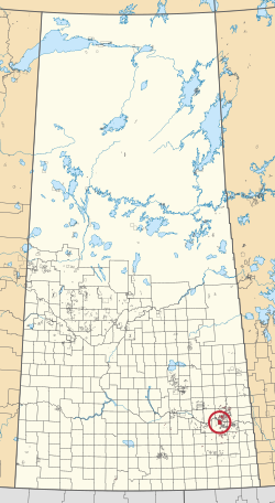
 Location in Saskatchewan | |
| First Nation | Cowessess |
| Country | Canada |
| Province | Saskatchewan |
| Area | |
• Total | 41,927.2 ha (103,604.4 acres) |
| Population (2016)[2] | |
• Total | 540 |
| • Density | 1.3/km2 (3.3/sq mi) |
| Community Well-Being Index[3] | 63 |
Cowessess 73 is an Indian reserve of the Cowessess First Nation in Saskatchewan.[1][4] It is 13 kilometres (8.1 mi) north-west of Broadview. In the 2016 Canadian Census, it recorded a population of 540 living in 190 of its 214 total private dwellings.[2] In the same year, its Community Well-Being index was calculated at 63 of 100, compared to 58.4 for the average First Nations community and 77.5 for the average non-Indigenous community.[3]
In June 2021, anomalies in the earth suspected of containing the remains of 751 children were found at the former Marieval Indian residential school in Marieval, part of the Canadian Indian residential school system, the most found in Canada to date.[5]
See also
[edit]References
[edit]- ^ a b "Reserve/Settlement/Village Detail". Crown–Indigenous Relations and Northern Affairs Canada. Government of Canada. Retrieved 12 August 2019.
- ^ a b "Census Profile, 2016 Census". Statistics Canada. 8 February 2017. Retrieved 10 August 2019.
- ^ a b "The Community Well-Being index". Indigenous Services Canada. 24 May 2019. Retrieved 9 October 2019.
- ^ "Canada Lands Survey System - CLSS Map Browser". Natural Resources Canada. Retrieved 9 October 2019.
- ^ "Sask. First Nation announces hundreds of unmarked graves found at former residential school site". Archived from the original on 23 June 2021.
50°34′55″N 102°40′17″W / 50.582°N 102.6714°W

