Coteau Holmes, Louisiana
Appearance
Coteau Holmes | |
|---|---|
 | |
| Country | United States |
| State | Louisiana |
| Parish | St. Martin |
| Time zone | UTC-6 (CST) |
| • Summer (DST) | UTC-5 (CDT) |
| Area code | 337 |
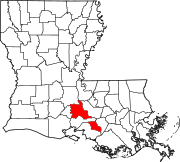
Coteau Holmes is an unincorporated community in St. Martin Parish, in the U.S. state of Louisiana.[1] LA 679 passes through the community. The nearest major town is Loreauville. It is part of the Lafayette Metropolitan Statistical Area.
Notes
[edit]30°07′48″N 91°43′34″W / 30.13000°N 91.72611°W

