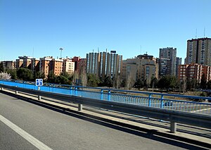
Costillares (Madrid)
This article needs additional citations for verification. (July 2023) |
Costillares | |
|---|---|
 | |
 | |
| Country | Spain |
| Autonomous community | Madrid |
| Municipality | Madrid |
| District | Ciudad Lineal |
| Area | |
• Total | 1.409 km2 (0.544 sq mi) |
| Population (2015) | |
• Total | 18,601 |
| • Density | 13,198/km2 (34,180/sq mi) |
Costillares [kostiˈʝaɾes], also known as Pinar de Chamartín [piˈnaɾ ðe tʃamaɾˈtin], is a neighborhood part of the Ciudad Lineal district, in north Madrid, Spain.
Neighborhood
[edit]The neighborhood has 18,601 residents.[1] It is named for a pinar (a small forest of pine trees) near the larger district of Chamartín. The current-day neighborhood, however, is located within the district of Ciudad Lineal.
Station
[edit]The station is the terminus for Line 1, Line 4 and the Metro Ligero line 1. As the 1 is one of the most important lines in all of Madrid, the 4 serves the local area of Hortaleza, and the ML1 serves the nearby Cercanías station in the new and expanding neighborhood of Sanchinarro, this station sees a high amount of traffic for being in a relatively low-population neighborhood far removed from the city center.
The station appears in the movie Doctor Zhivago and the neighborhood appears in the Spanish-language movie La cabina.
References
[edit]- ^ "Costillares". City Facts. Retrieved July 24, 2023.
