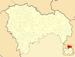
Cogolludo
Cogolludo, Spain | |
|---|---|
 General view of Cogolludo | |
| Coordinates: 40°56′54″N 3°05′15″W / 40.94833°N 3.08750°W | |
| Country | |
| Autonomous community | Castile-La Mancha |
| Province | Guadalajara |
| Municipality | Cogolludo |
| Area | |
| • Total | 96 km2 (37 sq mi) |
| Population (2018)[1] | |
| • Total | 549 |
| • Density | 5.7/km2 (15/sq mi) |
| Time zone | UTC+1 (CET) |
| • Summer (DST) | UTC+2 (CEST) |
Cogolludo is a municipality located in the province of Guadalajara, Castile-La Mancha, Spain. It forms part of the comarca of La Serranía and was the manorial home of the Dukes of Medinaceli. In 2015, it had a population of 600 inhabitants. The historic Church of Santa María stands in the town.
Name and symbols
[edit]Its original name was Cugullent, from the Latin cucullus, which means "cap." This alludes to its location on a hill and to the crowding of its houses that mimics the appearance of a pineapple or bud. "Bud" would come to mean, according to other authors, "mound with a steep slope."
The municipal coat of arms - approved by decree on December 20, 1985 - is the following:
Cut: 1st and 4th part, made of gules, golden tower masoned with sable and clarified with gules; silver match the rampant lion of gules; 2nd and 3rd, of azure, three golden lyses, 2-1. At the top, royal crown closed.
 -Official Gazette of Castilla-La Mancha No. 52 of December 31, 1985
The municipal flag is a cloth of 2:3 proportions of crimson red color with the municipal coat of arms in the center.
Notable people
[edit]References
[edit]- ^ Municipal Register of Spain 2018. National Statistics Institute.
-
Church of Santa María
-
Cogolludo municipal office
-
San Pedro Church
-
Ruins of the Castle of Cogolludo


