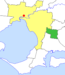
City of Berwick
| City of Berwick Victoria | |||||||||||||||
|---|---|---|---|---|---|---|---|---|---|---|---|---|---|---|---|
 Location in Melbourne | |||||||||||||||
| Population | 75,400 (1992)[1] | ||||||||||||||
| • Density | 626.1/km2 (1,621.6/sq mi) | ||||||||||||||
| Established | 1973 | ||||||||||||||
| Area | 120.43 km2 (46.5 sq mi) | ||||||||||||||
| Council seat | Narre Warren | ||||||||||||||
| Region | Outer Southeast Melbourne | ||||||||||||||
| County | Mornington | ||||||||||||||
 | |||||||||||||||
The City of Berwick was a local government area about 40 kilometres (25 mi) southeast of Melbourne, the state capital of Victoria, Australia. The city covered an area of 120.43 square kilometres (46.50 sq mi), and existed from 1973 until 1994.
History
[edit]The area which came under the City of Berwick had previously been the Berwick and Doveton ridings of the Shire of Berwick. It had been incorporated as the Berwick Road District on 24 October 1862 and became a shire on 12 May 1868. On 1 October 1973, the area surrounding Berwick and Narre Warren, which was undergoing rapid population growth and urbanisation, split from the shire and was proclaimed a city.[2]
On 15 December 1994, the City of Berwick was abolished, and along with parts of the City of Cranbourne, was merged into the newly created City of Casey. The Doveton industrial district was transferred to the newly created City of Greater Dandenong.[3]
Council met at the Narre Warren Civic Centre, adjacent to Westfield Fountain Gate, in Narre Warren. The facility continued to remain in use by the City of Casey until its replacement by Bunjil Place in the late 2010s. It was subsequently demolished.
Wards
[edit]The City of Berwick was divided into four wards, each of which elected three councillors:
- Centre Ward
- East Ward
- North Ward
- South Ward
Suburbs
[edit]- Beaconsfield (shared with the Shire of Pakenham)
- Berwick
- Doveton
- Endeavour Hills
- Eumemmering
- Hallam
- Harkaway
- Narre Warren*
- Narre Warren North
- Narre Warren South
* Council seat.
Population
[edit]| Year | Population |
|---|---|
| 1971 | 20,474 |
| 1976 | 25,616 |
| 1981 | 36,181 |
| 1986 | 48,677 |
| 1991 | 69,144 |
| 2016 | 47,614 |
References
[edit]- ^ Australian Bureau of Statistics, Victoria Office (1994). Victorian Year Book. p. 49. ISSN 0067-1223.
- ^ Victorian Municipal Directory. Brunswick: Arnall & Jackson. 1992. pp. 311–312, 805–806. Accessed at State Library of Victoria, La Trobe Reading Room.
- ^ Australian Bureau of Statistics (1 August 1995). Victorian local government amalgamations 1994-1995: Changes to the Australian Standard Geographical Classification (PDF). Commonwealth of Australia. pp. 5–6. ISBN 0-642-23117-6. Retrieved 16 December 2007.
4. 2016 Australian census population of Berwick, Victoria
