Chyandour Brook

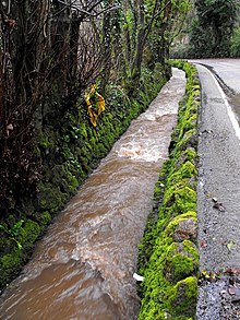
Chyandour Brook is a small river (brook) in west Cornwall, England. Rising in Boskednan in the civil parish of Madron, Chyandour Brook drains into Mount's Bay in the English Channel at Chyandour, Penzance.[1]
Course
[edit]Located entirely in the west of Cornwall, Chyandour Brook rises in the Penwith Moors in Boskednan, civil parish of Madron, and flows a southeasterly course. After flowing past the village of Madron, Chyandour Brook turns east through Heamoor, in the civil parish of Penzance. It then flows through Treneere—a residential council estate—before resuming a southeasterly course into Chyandour, where it drains into Mount's Bay in the English Channel.[1][2]
Flooding
[edit]Chyandour Brook has overflown on several occasions, with many significant flooding incidents between 2002 and 2014.[3] The Environment Agency, a non-departmental public body sponsored by the United Kingdom's Department for Environment, Food and Rural Affairs, declares most of the surrounding area of Chyandour Brook in Flood zone 3, indicating a "high probability of flooding."[4]
References
[edit]- ^ a b Map of Land's End & Isles of Scilly: St Ives & Lizard Point (Map). 1:50,000. OS Landranger. Ordnance Survey. 25 September 2020. Retrieved 8 October 2022.
- ^ Cornwall Council 2017, p. 12–13.
- ^ Cornwall Council 2017, p. 13.
- ^ "Chyandour Brook" (Map). Flood map for planning (PDF). 1:50:000. Cartography by Ordnance Survey. Environment Agency. 8 October 2022. p. 2. Retrieved 8 October 2022 – via the Internet Archive.
Sources
[edit]- Cornwall Council (7 August 2017). Cornwall Site Allocations Development Plan Document (Allocations DPD): Pre-Submission (Regulation 19) Consultation (PDF) (Report). Cornwall Council. Retrieved 8 October 2022.
50°07′30″N 5°31′40″W / 50.1250°N 5.5279°W
