Church of Saint Peter, Céret
Appearance
| Église Saint-Pierre de Céret | |
|---|---|
 Church of St. Peter: Western Façade | |
| Religion | |
| Affiliation | Roman Catholic Church |
| District | Roman Catholic Diocese of Perpignan-Elne |
| Province | Pyrénées-Orientales |
| Region | Occitanie |
| Status | Active |
| Location | |
| Location | Céret, France |
| Municipality | Céret |
| Architecture | |
| Type | church |
| Style | partly Romanesque |
| Groundbreaking | 11th century |
| Completed | 18th century |
| Specifications | |
| Direction of façade | West |
| Materials | stone |
| Designated as NHL | Monument historique (1998) |
Saint Peter is a Roman Catholic church in Céret, southern France. Mentioned for the first time in 814, the present day church was built and rebuilt several times from the 11th to the 18th centuries. It was declared a national monument in 1998.[1]
Gallery
[edit]-
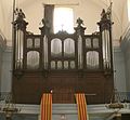
The great organ.
-
The portal.
-
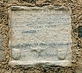
Funeral inscription of Bérengère de Valcrose.
-
Memorial inscription of the portal's construction (1398).
-
South portal.
-
Funeral inscription of Bernard de Céret and his wife.
The Great Organ
[edit]The organ of Saint-Pierre Church is the largest Romantic instrument in the Eastern Pyrenees, second only to the one in Perpignan Cathedral. Its composition is as follows: [2][3]
| I. Great | II. Choir | III. Swell | Pedal |
|---|---|---|---|
| Montre 16' | Bourdon 16' | Flûte traversière 8' | Bombarde 16' |
| Montre 8' | Flûte 8' | Trompette 8' | Trompette 8' |
| Basson 16' | Gambe 8' | Gambe 8' | Clairon 4' |
| Kéraulophone 8' | Voix humaine 8' | Bourdon 8' | Flûte 16' |
| Bourdon 8' | Trompette 8' | Bassons-Hautbois 8' | Flûte 8' |
| Trompette 8' | Salicional 8' | Flûte octave 4' | Flute 4' |
| Flûte harmonique 8' | Clarinette 8' | Clairon 4' | |
| Prestant 4' | Flûte 4' | Voix Céleste 8' | |
| Clairon 4' | Doublette 2' | Flûte octavin 2' | |
| Doublette 2' | |||
| Cornet V | |||
| Fourniture IV |
External links
[edit]Wikimedia Commons has media related to Church of Saint Peter, Céret.
- Base Mérimée: Église Saint-Pierre, Ministère français de la Culture. (in French)
Bibliography
[edit]- Mallet, Géraldine (2003). Églises romanes oubliées du Roussillon (in French). Montpellier: Les Presses du Languedoc. ISBN 978-2-8599-8244-7.
References
[edit]- ^ Base Mérimée: Church of Saint Peter, Céret, Ministère français de la Culture. (in French)
- ^ Verified information on-site
- ^ Orgue en France. "Inventaire national des orgues - église Saint-Pierre de Céret". Inventaire national des orgues. Retrieved August 15, 2023.
42°29′07″N 2°44′53″E / 42.48528°N 2.74806°E


