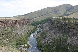
Chuluut River
Appearance
| Chuluut River Chuluut gol | |
|---|---|
 | |
 | |
| Etymology | Mongolian: chuluut, "stony" |
| Native name | Чулуут гол (Mongolian) |
| Location | |
| Country | Mongolia |
| Aimags | Arkhangai, Khövsgöl |
| Physical characteristics | |
| Source | |
| • location | Khangai Mountains |
| Mouth | Ider River |
| Length | 415 km (258 mi) |
| Basin size | 10,750 km2 (4,150 sq mi) |
| Basin features | |
| Progression | Ider→ Selenga→ Lake Baikal→ Angara→ Yenisey→ Kara Sea |
| Tributaries | |
| • left | Suman River |
Chuluut River (Mongolian: Чулуут гол, stony river) is a river flowing through the valleys of the Khangai Mountains in central Mongolia, and a tributary of the Ider River. It is 415 km long, the width at the mouth into the Ider river is 80 m, the maximum depth is 3 m. It is usually frozen from November to April.
References
[edit]"Чулуутын гол". medeelel.mn. Archived from the original on March 3, 2016. Retrieved July 16, 2007.
M.Nyamaa, Khövsgöl aimgiin lavlakh toli, Ulaanbaatar 2001
Wikimedia Commons has media related to Chuluut River.
49°12′37″N 100°40′14″E / 49.21028°N 100.67056°E
