Chesterfield Heights Historic District
Appearance
Chesterfield Heights Historic District | |
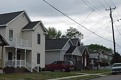
 Houses on Kimball Terrace | |
| Location | Roughly bounded by the East Branch Elizabeth River, Ballentine Boulevard, Sedgewick Street, and I-264, Norfolk, Virginia |
|---|---|
| Coordinates | 36°50′34″N 76°15′28″W / 36.84278°N 76.25778°W |
| Area | 85 acres (34 ha) |
| Built | 1898 |
| Architectural style | Queen Anne, Italianate, et al. |
| NRHP reference No. | 03000443[1] |
| VLR No. | 122-1201 |
| Significant dates | |
| Added to NRHP | June 10, 2003 |
| Designated VLR | December 4, 2002[2] |
The Chesterfield Heights Historic District is a national historic district located at Norfolk, Virginia. It encompasses 402 contributing buildings, 1 contributing site, and 1 contributing structure in a cohesive residential neighborhood located just to the northeast of downtown Norfolk. It was platted in 1904, and largely developed between 1915 and 1950. There are notable examples of Queen Anne and Italianate style residential architecture. Notable non-residential buildings include the St. Luke's Holiness Church of Christ's Disciples (c. 1950), Monticello Baptist Church (1925), and the Garrett Community Church (1940).[3]
It was listed on the National Register of Historic Places in 2003.[1]
References
[edit]- ^ a b "National Register Information System". National Register of Historic Places. National Park Service. July 9, 2010.
- ^ "Virginia Landmarks Register". Virginia Department of Historic Resources. Archived from the original on September 21, 2013. Retrieved March 19, 2013.
- ^ Laura V. Trieschmann and Jennifer J. Bunting (July 2002). "National Register of Historic Places Inventory/Nomination: Chesterfield Heights Historic District" (PDF). Virginia Department of Historic Resources. and Accompanying four photos and Accompanying map Archived November 11, 2013, at the Wayback Machine
Categories:
- Houses on the National Register of Historic Places in Virginia
- Historic districts on the National Register of Historic Places in Virginia
- National Register of Historic Places in Norfolk, Virginia
- Italianate architecture in Virginia
- Queen Anne architecture in Virginia
- Neighborhoods in Norfolk, Virginia
- Houses in Norfolk, Virginia
- Hampton Roads, Virginia Registered Historic Place stubs


