Chengtoushan


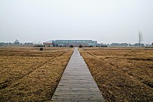
Chengtoushan (simplified Chinese: 城头山; traditional Chinese: 城頭山; pinyin: Chéngtóushān) was a Neolithic settlement located on the northwestern edge of Dongting Lake in Li County, Hunan, China.[1][2]
The site is at the village of Chengtoushan, Chengtoushan Town, Li County, it is about 12 kilometres (7 mi) northwest of the county seat and 8 kilometres (5 mi) north of the Li River.

The site contains one of the earliest dated rice paddies in the world (dating from 4500 to 3000 BC).[3][4] The settlement spanned three separate cultures: the Daxi culture, the Qujialing culture and the Shijiahe culture. The site was abandoned around the middle period of the Shijiahe culture.
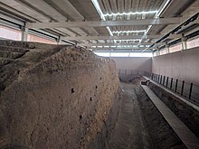
Chengtoushan was a round settlement surrounded by a moat and rammed earth wall, which was first built during the Daxi culture.[5] The remains of human sacrifices were discovered under the foundation of the wall. The remains of a gravel road, a river bridge and a river-control gate were also discovered at Chengtoushan. It is possibly one of the oldest walled sites in China, with the walls and moat built around 4000 BC, where it existed for two millennia.[6][7]
The earliest known examples of fired bricks were discovered at Chengtoushan, dating to around 4400 BC.[8] These bricks were made of red clay, which was obtained by digging into the loess strata. They were fired on all sides to above 600 °C, and used as flooring for houses. By the Qujialing period (3300 BC), fired bricks were being used to pave roads and as building foundations at Chengtoushan.[9]
Notes
[edit]- ^ ""国家名片"上的澧县城头山_旅游文化_澧县新闻网". www.lxxww.com.cn. Retrieved 2 May 2024.
- ^ "城头山,中国最古老的城-光明日报-光明网". epaper.gmw.cn. Retrieved 2 May 2024.
- ^ Archaeology of Asia, pp. 106
- ^ "大溪文化出土玉器初探 - 重庆考古". www.cqkaogu.com. Retrieved 2 May 2024.
- ^ "城头山:中国最早的城"醒来" - 深读湖南 - 湖南在线 - 华声在线". hunan.voc.com.cn. Retrieved 2 May 2024.
- ^ "从城头山到鸡叫城——澧阳平原还有多少未解之谜-中新网". www.chinanews.com.cn. Retrieved 2 May 2024.
- ^ "城头山遗址_全国重点文物保护单位_古迹寻踪_文化常德_走进常德_常德市人民政府门户网站". www.changde.gov.cn. Retrieved 2 May 2024.
- ^ Yoshinori Yasuda (2012). Water Civilization: From Yangtze to Khmer Civilizations. Springer Science & Business Media. pp. 30–31. ISBN 9784431541103.
- ^ Yoshinori Yasuda (2012). Water Civilization: From Yangtze to Khmer Civilizations. Springer Science & Business Media. pp. 33–35. ISBN 9784431541103.
References
[edit]- Allan, Sarah (ed.), The Formation of Chinese Civilization: An Archaeological Perspective, ISBN 0-300-09382-9
- Higham, Charles, The Bronze Age of Southeast Asia, ISBN 0-521-56505-7
- Stark, Miriam T. (ed.), Archaeology of Asia, 2006, ISBN 1-4051-0213-6
