Chalkhill, Pennsylvania
Appearance
(Redirected from Chalk Hill, Pennsylvania)
Chalk Hill, Pennsylvania
Chalk Hill | |
|---|---|
 Post office | |
| Coordinates: 39°50′46″N 79°36′51″W / 39.84611°N 79.61417°W | |
| Country | United States |
| State | Pennsylvania |
| County | Fayette |
| Township | Wharton |
| Area | |
• Total | 0.83 sq mi (2.15 km2) |
| • Land | 0.82 sq mi (2.12 km2) |
| • Water | 0.01 sq mi (0.03 km2) |
| Elevation | 2,060 ft (630 m) |
| Population | |
• Total | 127 |
| • Density | 155.07/sq mi (59.88/km2) |
| Time zone | UTC-5 (Eastern (EST)) |
| • Summer (DST) | UTC-4 (EDT) |
| ZIP code | 15421 |
| FIPS code | 42-12512 |
| GNIS feature ID | 2631254 |
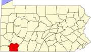
Chalk Hill is an unincorporated community and census-designated place in Wharton Township, Fayette County, Pennsylvania, United States. It is located along U.S. Route 40 (the National Road), approximately 8 miles (13 km) southeast of the city of Uniontown. As of the 2010 census, the population was 141.[3]
Climate
[edit]| Climate data for Chalkhill, Pennsylvania, 1991–2020 normals, 1977-2020 extremes: 1980ft (604m) | |||||||||||||
|---|---|---|---|---|---|---|---|---|---|---|---|---|---|
| Month | Jan | Feb | Mar | Apr | May | Jun | Jul | Aug | Sep | Oct | Nov | Dec | Year |
| Record high °F (°C) | 70 (21) |
75 (24) |
83 (28) |
87 (31) |
95 (35) |
92 (33) |
95 (35) |
91 (33) |
88 (31) |
83 (28) |
77 (25) |
73 (23) |
95 (35) |
| Mean maximum °F (°C) | 59.2 (15.1) |
59.8 (15.4) |
70.2 (21.2) |
79.7 (26.5) |
84.1 (28.9) |
85.3 (29.6) |
86.1 (30.1) |
84.7 (29.3) |
82.3 (27.9) |
75.8 (24.3) |
69.6 (20.9) |
58.9 (14.9) |
86.7 (30.4) |
| Mean daily maximum °F (°C) | 34.4 (1.3) |
38.3 (3.5) |
47.5 (8.6) |
60.7 (15.9) |
69.4 (20.8) |
75.2 (24.0) |
78.6 (25.9) |
76.9 (24.9) |
71.2 (21.8) |
60.8 (16.0) |
49.4 (9.7) |
38.7 (3.7) |
58.4 (14.7) |
| Daily mean °F (°C) | 24.9 (−3.9) |
27.4 (−2.6) |
35.5 (1.9) |
47.0 (8.3) |
56.3 (13.5) |
63.5 (17.5) |
67.1 (19.5) |
65.6 (18.7) |
59.2 (15.1) |
48.6 (9.2) |
38.3 (3.5) |
29.5 (−1.4) |
46.9 (8.3) |
| Mean daily minimum °F (°C) | 15.4 (−9.2) |
16.5 (−8.6) |
23.5 (−4.7) |
33.4 (0.8) |
43.2 (6.2) |
51.7 (10.9) |
55.5 (13.1) |
54.3 (12.4) |
47.1 (8.4) |
36.4 (2.4) |
27.3 (−2.6) |
20.2 (−6.6) |
35.4 (1.9) |
| Mean minimum °F (°C) | −7.1 (−21.7) |
−3.0 (−19.4) |
4.9 (−15.1) |
21.9 (−5.6) |
30.3 (−0.9) |
39.2 (4.0) |
45.7 (7.6) |
45.5 (7.5) |
35.3 (1.8) |
26.0 (−3.3) |
13.4 (−10.3) |
3.4 (−15.9) |
−7.7 (−22.1) |
| Record low °F (°C) | −27 (−33) |
−22 (−30) |
−14 (−26) |
7 (−14) |
20 (−7) |
31 (−1) |
37 (3) |
32 (0) |
29 (−2) |
18 (−8) |
2 (−17) |
−17 (−27) |
−27 (−33) |
| Average precipitation inches (mm) | 4.56 (116) |
4.11 (104) |
5.02 (128) |
4.72 (120) |
5.20 (132) |
5.74 (146) |
4.65 (118) |
4.54 (115) |
4.70 (119) |
3.80 (97) |
4.13 (105) |
4.51 (115) |
55.68 (1,415) |
| Average snowfall inches (cm) | 26.90 (68.3) |
18.00 (45.7) |
15.50 (39.4) |
3.70 (9.4) |
0.00 (0.00) |
0.00 (0.00) |
0.00 (0.00) |
0.00 (0.00) |
0.00 (0.00) |
0.90 (2.3) |
6.20 (15.7) |
17.60 (44.7) |
88.8 (225.5) |
| Source 1: NOAA[4] | |||||||||||||
| Source 2: XMACIS (temp records & monthly max/mins)[5] | |||||||||||||
Demographics
[edit]| Census | Pop. | Note | %± |
|---|---|---|---|
| 2020 | 127 | — | |
| U.S. Decennial Census[6][2] | |||
References
[edit]- ^ "ArcGIS REST Services Directory". United States Census Bureau. Retrieved October 12, 2022.
- ^ a b "Census Population API". United States Census Bureau. Retrieved October 12, 2022.
- ^ "Geographic Identifiers: 2010 Census Summary File 1 (G001), Chalkhill CDP, Pennsylvania". American FactFinder. U.S. Census Bureau. Archived from the original on February 13, 2020. Retrieved July 22, 2016.
- ^ "Chalk Hill 2 ENE, Pennsylvania 1991-2020 Monthly Normals". Retrieved December 11, 2023.
- ^ "xmACIS". National Oceanic and Atmospheric Administration. Retrieved December 11, 2023.
- ^ "Census of Population and Housing". Census.gov. Retrieved June 4, 2016.


