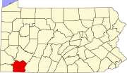
Allison, Pennsylvania
Appearance
Allison, Pennsylvania | |
|---|---|
| Coordinates: 39°59′14″N 79°52′10″W / 39.98722°N 79.86944°W | |
| Country | United States |
| State | Pennsylvania |
| County | Fayette |
| Townships | Luzerne, Redstone |
| Area | |
| • Total | 0.68 sq mi (1.75 km2) |
| • Land | 0.67 sq mi (1.74 km2) |
| • Water | 0.00 sq mi (0.01 km2) |
| Elevation | 980 ft (300 m) |
| Population | |
| • Total | 503 |
| • Density | 747.40/sq mi (288.52/km2) |
| Time zone | UTC-5 (Eastern (EST)) |
| • Summer (DST) | UTC-4 (EDT) |
| ZIP code | 15413 |
| FIPS code | 42-02040 |
| GNIS feature ID | 1192067 |
Allison is an unincorporated community and census-designated place (CDP), which is located in Luzerne and Redstone townships in Fayette County, Pennsylvania, United States. It is situated 3 miles (5 km) south of the borough of Brownsville.
As of the 2010 census, the population was 625.[3] The CDP includes the neighborhood of Allison Heights in Luzerne Township.
Dunlap Creek flows through the center of the CDP, forming the border between Luzerne and Redstone townships.
Demographics
[edit]Between the time of the 2010 and 2020 federal census counts, the population declined to 503.[4][2]
References
[edit]- ^ "ArcGIS REST Services Directory". United States Census Bureau. Retrieved October 12, 2022.
- ^ a b "Census Population API". United States Census Bureau. Retrieved October 12, 2022.
- ^ "Geographic Identifiers: 2010 Census Summary File 1 (G001), Allison CDP, Pennsylvania". American FactFinder. U.S. Census Bureau. Archived from the original on February 13, 2020. Retrieved July 22, 2016.
- ^ "Census of Population and Housing". Census.gov. Retrieved June 4, 2016.


