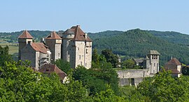
Curemonte
You can help expand this article with text translated from the corresponding article in French. (January 2009) Click [show] for important translation instructions.
|
Curemonte | |
|---|---|
 The Château des Plas, in Curemonte | |
| Coordinates: 45°00′00″N 1°44′27″E / 44.9999°N 1.7409°E | |
| Country | France |
| Region | Nouvelle-Aquitaine |
| Department | Corrèze |
| Arrondissement | Brive-la-Gaillarde |
| Canton | Midi Corrézien |
| Intercommunality | Midi Corrézien |
| Government | |
| • Mayor (2020–2026) | Nelly Germane[1] |
Area 1 | 8.83 km2 (3.41 sq mi) |
| Population (2021)[2] | 212 |
| • Density | 24/km2 (62/sq mi) |
| Time zone | UTC+01:00 (CET) |
| • Summer (DST) | UTC+02:00 (CEST) |
| INSEE/Postal code | 19067 /19500 |
| Elevation | 143 m (469 ft) |
| 1 French Land Register data, which excludes lakes, ponds, glaciers > 1 km2 (0.386 sq mi or 247 acres) and river estuaries. | |
Curemonte (French pronunciation: [kyʁmɔ̃t]; Limousin: Curamonta) is a commune in the Corrèze department in central France. It is a medieval village characterised by its three castles. In a fortified position on a ridge overlooking a valley on both its eastern and western flanks, the village has historically had a strategic importance in the area. Curemonte is a member of Les Plus Beaux Villages de France (The Most Beautiful Villages of France) Association. Its inhabitants are called Curemontois.
Toponymy
[edit]The name for Curemonte is derived from low Latin Cura montis meaning a location used for an operating estate that's on a mountain or hill.[3]: 25
History
[edit]The existence of Curemonte is confirmed from as early as 860 when it was mentioned in the Cartulaire de l'Abbaye de Beaulieu.[3]: 25 Rodolphe de Turenne, Archbishop of Bourges, had donated the village of Saint-Genst and its vineyards at Curemonte to the Abbey of Beaulieu.[3]: 25
It was in the 11th century that the village flourished, passing through the Viscounts of Turenne.
Geography
[edit]Location
[edit]The municipality of Curemonte is located at the southern end of the department of Corrèze.

Physical geography
[edit]The village of Curemonte is built on a ridge line that overlooks the valleys of the Sourdoire and the Maumont.
Demographics
[edit]| Year | Pop. | ±% p.a. |
|---|---|---|
| 1968 | 311 | — |
| 1975 | 248 | −3.18% |
| 1982 | 231 | −1.01% |
| 1990 | 203 | −1.60% |
| 1999 | 225 | +1.15% |
| 2009 | 213 | −0.55% |
| 2014 | 216 | +0.28% |
| 2020 | 208 | −0.63% |
| Source: INSEE[4] | ||
Places and monuments
[edit]- It is ranked among the most beautiful villages in France.
- It has three castles:
- It has three churches:
- Church of Saint-Barthélemy du Bourg;
- Church of Saint-Hilaire de la Combe: 11th Century Romanesque church, one of the oldest in the department, which was probably built on Merovingian foundations;
- The church of Saint-Genest: former parish church, now a Museum of Religious Art.
-
Châteaux de Plas et de Saint-Hilaire.
-
Church of Saint-Barthélemy.
-
Church of Saint-Hilaire de la Combe.
See also
[edit]References
[edit]- ^ "Répertoire national des élus: les maires". data.gouv.fr, Plateforme ouverte des données publiques françaises (in French). 9 August 2021.
- ^ "Populations légales 2021" (in French). The National Institute of Statistics and Economic Studies. 28 December 2023.
- ^ a b c Lalé, Jean (1994). Curemonte. Chronique d'une Renaissance (in French). Treignac: Les Monédières. ISBN 2-903438-11-X. OCLC 12134959.
{{cite book}}: Check|isbn=value: checksum (help) - ^ Population en historique depuis 1968, INSEE
- ^ Base Mérimée: Châteaux de Saint-Hilaire et des Plas, Ministère français de la Culture. (in French)
- ^ Base Mérimée: Château de la Johannie, Ministère français de la Culture. (in French)


