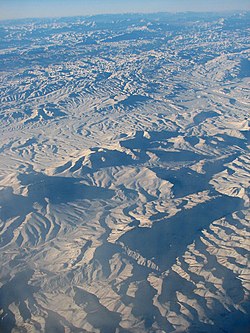
Central Makran Range
Appearance
| Central Makran Range | |
|---|---|
| Highest point | |
| Elevation | 3,000 m (9,800 ft) |
| Geography | |
| Location | Balochistan, Pakistan |
| Parent range | Makran region |
| Geology | |
| Rock age(s) | Formed by the collision of the northwestern Indian Plate and the Asian Plate |
| Mountain type | Mountain range |
| Rock type(s) | Primarily limestone and sandstone |


The Central Makran Range is a mountain range in the Makran region, in southwestern section of Balochistan Province, in southwestern Pakistan.
Geography
[edit]It is one of three ranges in the mountain ranges system of the province. The range's peaks are 2,000–3,000 metres (6,600–9,800 ft) in elevation.
Mirani Dam across the Dasht River forms a reservoir in the range, to provide irrigation water in the region and drinking water for the city of Gwadar.
Geology
[edit]The Central Makran Range is primarily made up of limestone and sandstone. It was formed when the northwestern Indian Plate collided with the Asian Plate.
Adjacent ranges
[edit]There are three main ranges in Balochistan:
- the Makran Coastal Range (up to about 1,500 metres (4,900 ft));
- the Central Makran Range (2,000–3,000 metres (6,600–9,800 ft));
- the Siahan Range (1,000–2,000 metres (3,300–6,600 ft)).
See also
[edit]References
[edit]External links
[edit]Wikimedia Commons has media related to Central Makran Range, Pakistan.
26°40′N 64°30′E / 26.667°N 64.500°E

