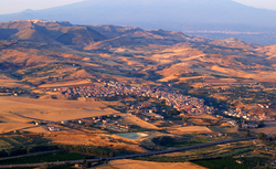
Catenanuova
You can help expand this article with text translated from the corresponding article in Italian. (January 2022) Click [show] for important translation instructions.
|
Catenanuova | |
|---|---|
| Comune di Catenanuova | |
 | |
| Coordinates: 37°34′N 14°41′E / 37.567°N 14.683°E | |
| Country | Italy |
| Region | Sicily |
| Province | Enna (EN) |
| Government | |
| • Mayor | Carmelo Scravaglieri |
| Area | |
• Total | 11.22 km2 (4.33 sq mi) |
| Elevation | 170 m (560 ft) |
| Population (10 June 2018)[2] | |
• Total | 5,483 |
| • Density | 490/km2 (1,300/sq mi) |
| Demonym | Catenanuovesi |
| Time zone | UTC+1 (CET) |
| • Summer (DST) | UTC+2 (CEST) |
| Postal code | 94010 |
| Dialing code | 0935 |
| Patron saint | St. Prosper |
| Saint day | Last Sunday in September |
| Website | Official website |
Catenanuova (Sicilian: Catinanova) is a town and comune in the province of Enna, in the region of Sicily in southern Italy.
Geography
[edit]Catenanuova is located in the Dittaino valley, 38 km (24 mi) East from its provincial capital Enna and 35 km (22 mi) west from Catania. It is connected to the latter and to Palermo by both railway and the A19 highway.
Climate
[edit]Catenanuova's ambient temperature and rainfall are recorded by a remote telemetry station operated by Sicily's Department of Water and Waste,[3] which on August 10, 1999 measured a maximum of 48.5 °C (119.3 °F),.[4] However, Catenanuova is not a World Meteorological Organization surface station – the nearest being c.37 km (23 mi) away at Enna[5][6] – and the WMO's officially recognized European maximum is 48.8 °C (119.8 °F), recorded on August 11, 2021 in Floridia, Sicily.[7]
History
[edit]Catenanuova was founded between 1727 and 1733 by Andrea Giuseppe Riggio-Statella, Prince of Aci Catena, to fulfil the last wishes of his mother, the Baroness Anna Maria Statella (died 1717) who wanted "to revive happy memories of childhood" after the 1693 Sicily earthquake had decimated her husband's family.[8] A notarized document dated February 9, 1733 attests to the existence of Catenanuova at that date.[8] Between 1731 and 1736 Catenanuova became a small urban center with full autonomy. The name of the town derived from Aci Catena and changed from Terra della Nuova Catena to Catena la Nuova to the present Catenanuova.
Economy
[edit]Catenanuova is classified as rural municipality.[9] The main activities are agriculture (wheat, citrus, vegetables), and craft manufacturing (in iron and wood). The entrepreneurship index of Catenanuova was 43.27/1000 pop in 2001.[10]
References
[edit]- ^ "Superficie di Comuni Province e Regioni italiane al 9 ottobre 2011". Italian National Institute of Statistics. Retrieved 16 March 2019.
- ^ "Popolazione Residente al 1° Gennaio 2018". Italian National Institute of Statistics. Retrieved 16 March 2019.
- ^ "Alert zone H". Osservatorio delle Acque (Water Monitoring) Real-time data. Dipartimento dell'Acqua e dei Rifiuti. Retrieved 2011-02-04.
- ^ "Table I – Daily temperature readings". Osservatorio delle Acque (Water Monitoring) Annual data. Dipartimento dell'Acqua e dei Rifiuti. 1999. p. 60. Archived from the original on 2013-04-01. Retrieved 2011-02-04.
- ^ "WMO Publication No. 9, Volume A, Observing Stations". World Meteorological Organization.
- ^ "Weather reports worldwide: Enna (16450)". MeteoGroup. Archived from the original on 2011-01-01. Retrieved 2011-02-04.
- ^ "WMO is monitoring potential new temperature records". public.wmo.int. 2023-07-17. Retrieved 2023-07-19.
- ^ a b "Comune di Catenanuova, storia e turismo". Comune di Catenanuova (EN). Archived from the original on 2011-07-22.
- ^ ISTAT (Italian National Institute of Statistics). "Statistical Atlas of Municipalities. 2009 edition" (included CD-Rom). ISBN 978-88-458-1630-7
- ^ "Atlante Socioeconomico della Sicilia". Regione Siciliana, Atlante Statistico della Regione Siciliana. Archived from the original on 2011-06-29.


