Castlerahan
Castlerahan
Caisleán Raithin (Irish) | |
|---|---|
 View of Lough Ramor | |
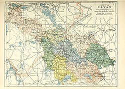
 Barony map of County Cavan, 1900; Castlerahan is in the southeast, coloured peach. | |
| Sovereign state | Ireland |
| Province | Ulster |
| County | Cavan |
| Area | |
• Total | 280.36 km2 (108.25 sq mi) |
Castlerahan (Irish: Caisleán Raithin[1]) is a barony in County Cavan, Ireland.[2] Baronies were mainly cadastral rather than administrative units. They acquired modest local taxation and spending functions in the 19th century before being superseded by the Local Government (Ireland) Act 1898.[3][4]
Etymology
[edit]Castlerahan barony takes its name from Castlerahan townland, from Castlera[c]han, an ancient hillfort located at 53°49′26″N 7°11′17″W / 53.824°N 7.188°W. The name is derived from Irish Caisleán Raithín, "stone fort of the little ringfort," although other writers link it with raithean, "bracken", or with a Norse Gael leader named Raithin.[5][6]
Geography
[edit]Castlerahan is located in the southeast of County Cavan, the area surrounding Lough Ramor.[7]
History
[edit]
The Luigni tribe lived in the area since the 8th century. It contains the parish of Munterconnaught, named for Cu Connaght Ua Raghallaigh (O'Reilly).[8] The barony of Castlerahan was created by 1609 in the Plantation of Ulster, and was archaically spelled Castlerachan.[9]
The barony gives its name to Castlerahan GAA, based in Ballyjamesduff.[10]
List of settlements
[edit]Below is a list of settlements in Castlerahan:
References
[edit]- ^ "Caisleán Raithin/Castlerahan". Logainm.ie.
- ^ General Alphabetical Index to the Townlands and Towns, Parishes, and Baronies of Ireland: Based on the Census of Ireland for the Year 1851. Genealogical Publishing Com. 22 February 1984. ISBN 9780806310527 – via Google Books.
- ^ Sharp, James A. (22 February 1852). "A new gazetteer; or topographical dictionary of the British islands and narrow seas". LONGMAN, BROWN – via Google Books.
- ^ General Register Office of Ireland (1904). "Alphabetical index to the baronies of Ireland". Census of Ireland 1901: General topographical index. Command papers. Vol. Cd. 2071. HMSO. pp. 966–978.
- ^ "Caisleán Raithin/Castlerahan". Logainm.ie.
- ^ "CASTLERAHAN, a parish - Topographical Dictionary of Ireland (1837)". www.libraryireland.com.
- ^ O'Connell, Philip (22 February 1920). "Historical notes on Virginia and Lough Ramor". sources.nli.ie.
- ^ "The Baronies of Ireland - History". sites.rootsweb.com.
- ^ MacNevin, Thomas (22 February 1846). "The confiscation of Ulster ... commonly called the Ulster plantation". J. Duffy – via Google Books.
- ^ ""Everyone told us we were too old and that the best was gone from this team"". SportsJOE.ie.

