Carlshem
Appearance
Carlshem | |
|---|---|
Residential area | |
 Apartment building typical for the area. | |
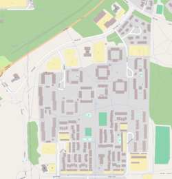
 Map of Carlshem, from OpenStreetMap | |
| Coordinates: 63°48′06″N 20°19′09″E / 63.80167°N 20.31917°E | |
| Country | Sweden |
| Province | Västerbotten |
| County | Västerbotten County |
| Municipality | Umeå Municipality |
| Time zone | UTC+1 (CET) |
| • Summer (DST) | UTC+2 (CEST) |
Carlshem is a residential area in southeastern Umeå, Sweden, located about 5 kilometers from central Umeå. Most of the area were built in the 1970s.[1]
The area consists of both townhouses, villas and apartment buildings with two or three storeys. There are both regular rental apartments and student flats. The area also includes a hair salon and a restaurant.
There is a church in the area, Carlskyrkan, which opened in 1984.[2] A hotel and spa is planned to be built in the area.[3]
History
[edit]The names Carlshem, Carlslid, and Carlshöjd originate from the inn Carlslund, which at the end of the 18th century was located where Älvans väg in Tomtebo exists today.
-
Carlskyrkan
-
Milano, a restaurant at Carlshem.
References
[edit]- ^ "Carlshem, Carlslid och Carlshöjd" (in Swedish). Umeå Municipality. Archived from the original on 10 December 2011. Retrieved 16 September 2011.
- ^ "Carlskyrkan" (in Swedish). Church of Sweden. Archived from the original on 8 October 2012. Retrieved 16 September 2011.
- ^ "Hotell byggs vid Kolbäcksleden". Västerbottens-Kuriren (in Swedish). 16 June 2010. Archived from the original on 25 May 2024. Retrieved 16 September 2011.
External links
[edit]- Carlshem at Umeå Municipality
- Carlshem in Google Maps


