Carl G. Washburne Memorial State Park
Appearance
| Carl G. Washburne Memorial State Park | |
|---|---|
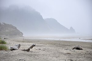
 Heceta Head as seen from the park beach | |
| Type | Public, state |
| Location | Lane County, Oregon |
| Nearest city | Waldport |
| Coordinates | 44°09′29″N 124°06′59″W / 44.1581765°N 124.1165087°W[1] |
| Operated by | Oregon Parks and Recreation Department |
Carl G. Washburne Memorial State Park is a state park in the U.S. state of Oregon, administered by the Oregon Parks and Recreation Department. This park is in Lane County near Florence and Yachats. Very scenic wide beach, great for dogs, kids, kites. Some areas nearby are SNOWY PLOVER protected breeding areas, where dogs are banned, so be careful to keep dogs leashed if uncertain, and always in the State Park itself.
Hobbit Trail
[edit]South of the park is the Hobbit Trail trail head located at mile 177.3[2] or 44°16′42″N 124°06′49″W / 44.278421°N 124.113499°W.
See also
[edit]References
[edit]- ^ "Carl G Washburne Memorial State Park". Geographic Names Information System. United States Geological Survey, United States Department of the Interior. Retrieved June 26, 2011.
- ^ Oregon Coast. Mile-by-Mile Guide. 2013, p. 42.
External links
[edit]- "Carl G. Washburne Memorial State Park". Oregon Parks and Recreation Department. Retrieved June 26, 2011.


