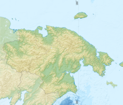
Cape Shelagsky
Appearance
Cape Shelagsky
Мыс Шелагский Erri / Ytrin | |
|---|---|
| Coordinates: 70°06′28″N 170°28′15″E / 70.10778°N 170.47083°E | |
| Location | Chukotka Autonomous Okrug, |
| Offshore water bodies | East Siberian Sea, Chaun Bay |
Cape Shelagsky or Cape Shelag (Russian: Мыс Шелагский; Chukot: Ытрин, romanized: Ytrin), also known as Erri by the Siberian Yupik,[1] is a headland situated in eastern Siberia, Russia on the shores of the East Siberian Sea.[2]
The cape was named after the Shelags, a little-known ethnic group that lived on the Arctic coast to the east of Cape Shelagsky.[3]
Geography
[edit]It is the eastern headland at the entrance of Chaun Bay. The cape is located at the western end of the Shelag Range, the northwesternmost subrange of the Chukotka Mountains.[4]
References
[edit]- ^ Arutyunov S. A & Sergeev D. A., Ancient cultures of the Asian Eskimos: (Uelen burial ground). Moscow: Nauka, 1968, p.210 ISBN 9785445835424
- ^ Google Earth
- ^ M. A. Sergeev, Экспедиция В.П. Врангеля и Ф.Ф. Матюшкина и изучение малых народов крайнего Северо-Востока. p. 416
- ^ Igor S. Zonn, Andrey G. Kostianoy, Aleksandr Semenov, The Eastern Arctic Seas Encyclopedia, Springer International Publishing Switzerland (2016), p. 68

