Cap-Rouge, Nova Scotia
Cap-Rouge | |
|---|---|
Former community | |
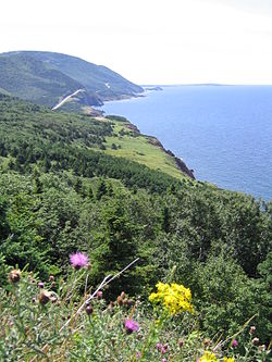
 Site of Cap-Rouge today | |
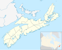
| Coordinates: 46°42′42″N 60°56′24″W / 46.71167°N 60.94000°W | |
| Country | |
| Province | |
| Inverness County, Nova Scotia | Cape Breton Highlands National Park |
| Time zone | UTC-4 (AST) |
| • Summer (DST) | UTC-3 (ADT) |
| NTS Map | 011K10 |
| GNBC Code | CBGMR |
Cap-Rouge was an Acadian village of some 30 families situated on Cape Breton Island, north of Chéticamp, in Nova Scotia, named for the nearby cape of the same name. The Cap Rouge region followed the western coast of Cape Breton Island, extending about seven miles to the north of Chéticamp. It included La Bloque, Ruisseau des Maurice (Trout Brook), Rivière à Lazare (Corney Brook) and Ruisseau du Canadien. Today however, the name Cap-Rouge is used to refer to all Acadian communities expropriated for the creation of the National Park, including the Rigouèche, the Buttereau, the Presqu’île and the Source de la Montain.[1][2]
History
[edit]
Some of the earliest grants of land in Cap-Rouge were made starting in 1826, with later grants following in 1864, 1867, 1868, and 1869. Other land concessions were awarded between 1873 and 1906.[1] The first school was opened in La Presqu'île around 1877 before later being located higher on the mountain in 1904. A Post Office was established June 1, 1899 at the home of Vieux Maurice Aucoin who become the first Postmaster.[3][1] Two lobster factories had already been established between 1900 and 1925. By 1936 the Cap-Rouge region included a sawmill located in La Rigoueche, a general store, a wharf, post office and school.[1]
Expropriation
[edit]The village properties were expropriated and the residents evacuated between 1936 and 1939 during the foundation of Cape Breton Highlands National Park, this despite the fact that many Scottish and English villages such as Pleasant Bay, and Ingonish were preserved.[4] [5] In the summer of 1940, on July 7, the Cap-Rouge post office was officially closed.[1]
Hiking Trail
[edit]The former village site is accessible today, by following a Parks Canada maintained trail, "Le vieux chemin du Cap-Rouge", located on the Cabot Trail across from the Trout Brook picnic area. Remains of an old school, foundations of the former residents' houses, and the old wharf at La Bloc visible at various points along the trail. An exhibit at the look-off at the south end of the trail provides further information on the families who used to live there.[6]
Further reading
[edit]- A history of Cap-Rouge and area was published in November 2019, "Cap Rouge: Ancien hameau de Chéticamp – Former Hamlet of Chéticamp", researched and authored by Ginette Chiasson.[7]
- Sandilands, Catriona (2011). "Cap Rouge Remembered? Whitness, Scenery, and Memory in Cape Breton Highlands National Park". In Baldwin, Andrew; Cameron, Laura; Kobayashi, Audrey (eds.). Rethinking the Great White North: Race, Nature, and the Historical Geographies of Whiteness in Canada. UBC Press. pp. 62–84. ISBN 9780774820165.
References
[edit]- ^ a b c d e Aucoin, Réjean (1985). Cap-Rouge: Sur Les Traces Des Habitants. Cheticamp: Les Amis du Plein Air / Parks Canada. ISBN 0969139241.
- ^ AuCoin-Grace, Rosie (22 November 2019). "Le livre Cap-Rouge : ancien hameau de Chéticamp lancé au parc national". Le Courrier de la Nouvelle-Écosse. Retrieved 12 December 2019.
- ^ Place-Names and Places of Nova Scotia. Public Archives of Nova Scotia. 1967. p. 109. Retrieved 11 December 2019.
- ^ Caplan, Ronald (August 1995). "Wilfred Creighton & the Expropriations: Clearing Land for the National Park, 1936". Cape Breton's Magazine. No. 69. Wreck Cove, Nova Scotia: Breton Books. pp. 1–20. Retrieved 4 July 2018.
- ^ MacEachern, Alan Andrew (23 April 2001). "Sublimity by the Sea: Establishing Cape Breton Highlands National Park, ca.1936". Natural Selections: National Parks in Atlantic Canada, 1935-1970. Montreal & Kingston: McGill-Queen's Press - MQUP. pp. 49, 54–56, 257, 283. ISBN 0773569014. Retrieved 23 November 2019.
- ^ "Le vieux chemin du Cap-Rouge". Parks Canada Agency. 14 September 2017. Retrieved 23 November 2019.
- ^ Aucoin-Grace, Rosie (6 November 2019). "Launching of book Cap Rouge - Former Hamlet of Chéticamp". The Inverness Oran. Inverness Communications Ltd. Retrieved 23 November 2019.


