Callan (barony)
Callan
Barony of Callan | |
|---|---|
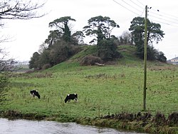
 Callan Motte in Callan. | |
| Etymology: Callow land[3] | |
Barony of Callan | |
| Coordinates: 52°32′50″N 7°24′6″W / 52.54722°N 7.40167°W | |
| Country | Ireland |
| Province | Leinster |
| County | County Kilkenny |
| Town of Callan | 1217 |
| Founded by | William Marshal, 1st Earl of Pembroke |
| Civil parishes | List
|
| Government | |
| • Type | County Council |
| • Body | Kilkenny County Council |
| Area | |
| • Total | 22.9 km2 (8.8 sq mi) |
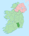
The barony of Callan (Irish: Callainn, meaning 'Callow land'[1][3]) is a barony in the west of County Kilkenny, Ireland.[1][6] The barony is 22.9 square kilometres (8.8 sq mi) in size.[5][7] It is one of 12 baronies in County Kilkenny.[2] Unusually for a barony, it contains only two civil parishes which together comprise 65 townlands.[1] The chief town is Callan.[1][8] The barony is bordered by the baronies of Shillelogher to the north (whose chief town is Bennettsbridge) and by Kells to the south (whose chief town is Kells). The N76 road bisects the barony. Notable features include Callan Motte and Callan Augustinian Friary.
Callan was an early medieval cantred within the shire of Kilkenny,[9] and part of the historic kingdom of Osraige (Ossory).[10] Today it is part of the Roman Catholic Church diocese of Ossory and the Church of Ireland diocese of Cashel and Ossory. Callan is currently administered by Kilkenny County Council.[4]
Etymology
[edit]The barony, town, and liberties, of Callan, take their name from the river Callainn, now the King's River.[10] The name in Irish, Callainn (pronounce Colling), comes from the Irish cala or caladh meaning, "callow land", and this refers to long coarse grass which grew in summer along the river bank after being waterlogged all winter.[3]
History
[edit]The barony was part of in the historic Gaelic kingdom of Osraige (Ossory) and the territory of the Ua Glóiairn clan of Callann.[9][10] According to O'Heerin's Topographical Poem (1420)[10] at the time of the Norman invasion the area was the territory of the clan called the Ua Glóiairn of Callann.[9][10] The Ó Glóiairn (O'Gloran) were chiefs of Callainn, the area of the "cantred of O'Glóiairn", lying on both sides of the King's River.[10] This later became the "Liberties of Callan".[9]
"O'Gloiairn, the fruit branch has got,
A cantred of a sweet country,
A smooth land along the beauteous Callainn,
A land without a particle of blemish."
Callan town and the surrounding area were a cantred in the 13th century, and the area was often included in the barony of Kells or Shillelogher. The town of Callan received a charter from William Marshal, 1st Earl of Pembroke in 1217. In the Down Survey (1656) it was called "Callan Liberties",[11] however, the 1836 Act explicitly states the town and liberties of Callan "shall be deemed and taken to be a barony".[12] The barony was recorded the 1840 Ordnance Survey map[13] and Griffith's Valuation (1864).[14]
In the 18th century County Kilkenny consisted of the Liberties of Kilkenny and of Callan and the baronies of Galmoy, Lower Ossory, Fassadinig, Cranagh, Shellilogher, Gowran, Kells, Knocktopher, Ida, Igrin, Iverk and Ibercon.[9] By the 19th century these were restructured into the baronies of Callan, Crannagh, Fassadinin, Galmoy, Gowran, Ida, Iverk, Kells, Knocktopher, and Shillelogher.[9]
Geography
[edit]
Today, the county of Kilkenny is subdivided into 12 baronies.[2] These include Kilkenny in the centre of the county, and clockwise from north of the county, Fassadinin, Gowran, Ida, Kilculliheen, Iverk, Knocktopher, Kells, Callan, Shillelogher, Crannagh, Galmoy.[15]
Callan lies to the west of the county, with the baronies of Shillelogher to the north and Kells to the south. Unusually for a barony, it contains only two civil parishes Callan and Killaloe.[8][16][17] It is made up of 65 townlands.[1] The Kings River flows through it, and was previously called the Callan River.
Places of interest include Callan Motte and Callan Augustinian Friary. Today it is part of the Roman Catholic Church diocese of Ossory and the Church of Ireland diocese of Cashel and Ossory. Callan is currently administered by Kilkenny County Council.[4] A single townland of 19 acres, Gortnasragh, which is an exclave of the civil parish of Killaloe, forms the remaining civil parish of the barony.[18][citation needed]
See also
[edit]- Barony (county division)
- Barony (Ireland)
- List of baronies of Ireland
- List of townlands of County Kilkenny
References
[edit]Footnotes
[edit]- ^ a b c d e f (Fiontar 2008, Barony of Callainn/Callan)
- ^ a b c (Government 2003 6 & 7 Will. 4. c. 116 § 154)
- ^ a b c d (Carrigan 1905, p. 25, Existing Civil Divisions or Baronies)
- ^ a b c (Kilkenny County County. "Website". kilkennycoco.ie.)
- ^ a b ("Barony of Callan, Co. Kilkenny". townlands.ie.)
- ^ (Tighe 1802, p. 4, Baronies)
- ^ (Parliament 1862, p. 971, Callan Barony)
- ^ a b (Fiontar 2008, Callan Civil Parishes)
- ^ a b c d e f (Walsh, Dennis. "Barony of Callan". ancestry.com., Walsh, Dennis. "Barony Map of the Leinster Region". ancestry.com., and Walsh, Dennis. "The Baronies of Ireland". ancestry.com.)
- ^ a b c d e f g (Ó hUidhrín & Ó Dubhagáin 1851, p. 7, PDF)
- ^ (Down Survey Project. "Callan Liberties Map". downsurvey.tcd.ie. The Down Survey Project.)
- ^ (Government 1836)
- ^ (OSI 2016, Historic Map 6 Inch Colour (1837–1842) )
- ^ (Griffith 1864, Callan Search)
- ^ (Fiontar 2008, County of Cill Chainnigh/Kilkenny)
- ^ (Fiontar 2008, Callan Civil Parish)
- ^ (Fiontar 2008, Killaloe Civil Parish)
- ^ Placenames Database of Ireland – townland of Gortnasragh
Sources
[edit]- Carrigan, William (1905). The History and Antiquities of the Diocese of Ossory. Middle Abbey Street, Dublin: Sealy, Bryers & Walker. ISBN 9785879206463.
- Fiontar (2008). "Placenames Database of Ireland". logainm.ie. Department of Arts, Heritage, Regional Rural and Gaeltacht Affairs of the Government of Ireland.
- Griffith, Richard John (1864). "Griffith's Valuation". www.askaboutireland.ie.
- Government (2003). Placenames (Co. Kilkenny) Order 2003 (PDF). Dublin: Government of Ireland. Archived from the original (PDF) on 10 February 2017. Retrieved 14 November 2018.
- Government (1836). Grand Jury (Ireland) Act, 1836. Dublin: Government of Ireland.
- Ó hUidhrín, Giolla na Naomh; Ó Dubhagáin, Seán Mór (1851). O'Donovan, John (ed.). The tribes and territories of ancient Ossory; comprising the portions of O'Heerin's and O'Dugan's topographical poems which relate to the families of that district. Dublin: J. O'Daly. ISBN 978-1-143-94749-0.
- OSI, Ordnance Survey Ireland (2016). "Ordnance Survey". osi.ie.
- Parliament (1862). General alphabetical index to townlands and towns, parishes and baronies of Ireland.
- Tighe, William (1802). Statistical observations relative to the county of Kilkenny: made in the years 1800 & 1801. Printed by Graisberry and Campbell.
External links
[edit]- Walsh, Dennis. "Barony of Callan". ancestry.com.
- Fiontar. "Barony of Callan". logainm.ie.
- "Barony of Callan, Co. Kilkenny". townlands.ie.


