Cañar Province
Appearance
(Redirected from Cañar Province, Ecuador)
Cañar | |
|---|---|
Province | |
| Province of Cañar | |
 | |
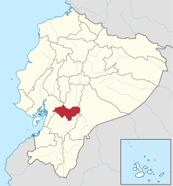
 Cañar Province in Ecuador | |
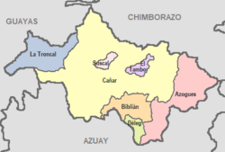
 Cantons of Cañar Province | |
| Country | |
| Established | November 4, 1880 |
| Recognized | April 25, 1884 |
| Named for | Cañari |
| Capital | Azogues |
| Cantons | List of cantons
|
| Government | |
| • Provincial Prefect | Marcelo Jaramillo (RC) |
| Area | |
• Total | 3,647 km2 (1,408 sq mi) |
| Population (2022 census)[1] | |
• Total | 227,578 |
| • Density | 62/km2 (160/sq mi) |
| Time zone | ECT |
| Vehicle registration | U |
| HDI (2017) | 0.727[2] high · 12th |
| Website | www |
Cañar (Spanish pronunciation: [kaˈɲaɾ]) is a province in Ecuador. The capital is Azogues. At the time of census 2010 the province had a population of 225,184.[3] It contains the 16th-century ruins of Ingapirca, the best-known Inca settlement in Ecuador and a product of their conquest of the indigenous Cañari.
Demographics
[edit]Ethnic groups as of the Ecuadorian census of 2010:[4]
- Mestizo 76.7%
- Indigenous 15.2%
- White 4.3%
- Afro-Ecuadorian 2.6%
- Montubio 1.1%
- Other 0.2%
Cantons
[edit]The province is divided into 7 cantons. The following table lists each with its population at the time of the 2001 census, its area in square kilometres (km²), and the name of the canton seat or capital.[5]
| Canton | Pop. (2019) | Area (km²) | Seat/Capital |
|---|---|---|---|
| Azogues | 85,030 | 613 | Azogues |
| Biblián | 23,590 | 227 | Biblián |
| Cañar | 68,190 | 1,804 | Cañar |
| Déleg | 6,760 | 78 | Déleg |
| El Tambo | 12,200 | 65 | El Tambo |
| Suscal | 6,390 | 31 | Suscal |
| La Troncal | 74,680 | 328 | La Troncal |
See also
[edit]References
[edit]- ^ Citypopulation.de
- ^ Villalba, Juan. "Human Development Index in Ecuador". Scribd (in Spanish). Retrieved 2019-02-05.
- ^ INEC, Población total y tasa brutas de natalidad, mortalidad general, mortalidad infantil y materna según regiones y provincias de residencia habitual, año 2005 Archived 2008-02-06 at the Wayback Machine, Retrieved October 13, 2007.
- ^ "Resultados" (PDF).
- ^ Cantons of Ecuador. Statoids.com. Retrieved 4 November 2009.
External links
[edit]- (in Spanish) Gobierno de la Provincia del Cañar, official website


