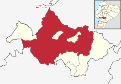
Cañar Canton
Appearance
Cañar, Ecuador | |
|---|---|
 Location of Cañar Province in Ecuador. | |
 Cañar Canton in Cañar Province | |
| Coordinates: 2°29′01″S 78°58′42″W / 2.4837°S 78.9784°W | |
| Country | |
| Province | Cañar Province |
| Elevation | 10,370 ft (3,160 m) |
| Time zone | UTC-5 (ECT) |
Cañar Canton is a canton of Ecuador, located in the Cañar Province. Its capital is the town of Cañar. Its population at the 2001 census was 58,185.[1]
Climate
[edit]| Climate data for Cañar, elevation 3,140 m (10,300 ft), (1971–2000) | |||||||||||||
|---|---|---|---|---|---|---|---|---|---|---|---|---|---|
| Month | Jan | Feb | Mar | Apr | May | Jun | Jul | Aug | Sep | Oct | Nov | Dec | Year |
| Mean daily maximum °C (°F) | 16.4 (61.5) |
16.0 (60.8) |
16.1 (61.0) |
16.0 (60.8) |
16.0 (60.8) |
15.3 (59.5) |
14.7 (58.5) |
15.2 (59.4) |
15.9 (60.6) |
16.7 (62.1) |
16.5 (61.7) |
16.8 (62.2) |
16.0 (60.7) |
| Mean daily minimum °C (°F) | 6.8 (44.2) |
7.0 (44.6) |
7.2 (45.0) |
7.1 (44.8) |
7.2 (45.0) |
6.3 (43.3) |
6.2 (43.2) |
6.4 (43.5) |
6.6 (43.9) |
6.5 (43.7) |
5.9 (42.6) |
6.4 (43.5) |
6.6 (43.9) |
| Average precipitation mm (inches) | 38.0 (1.50) |
54.0 (2.13) |
65.0 (2.56) |
65.0 (2.56) |
40.0 (1.57) |
26.0 (1.02) |
22.0 (0.87) |
18.0 (0.71) |
29.0 (1.14) |
46.0 (1.81) |
41.0 (1.61) |
32.0 (1.26) |
476 (18.74) |
| Average relative humidity (%) | 80 | 81 | 79 | 79 | 78 | 72 | 73 | 72 | 73 | 78 | 75 | 78 | 77 |
| Source: FAO[2] | |||||||||||||
References
[edit]- ^ Cantons of Ecuador at statoids.com
- ^ "CLIMWAT climatic database". Food and Agriculture Organization of United Nations. Retrieved 20 June 2024.
