Busokelo District
Appearance
This article is missing information about the new district. (July 2022) |
Busokelo
Wilaya ya Busokelo | |
|---|---|
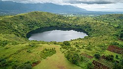
 Kiungululu Crater Lake | |
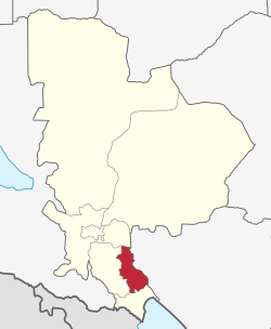
 Busokelo District of Mbeya Region | |
| Coordinates: 9°15′13″S 33°38′39″E / 9.253593°S 33.6441848°E | |
| Country | |
| Region | Mbeya Region |
| District | Busokelo |
| Established | 2013 |
| Headquarters | Lwangwa Town |
| Government | |
| • Type | Council |
| • Chairman | Anyosisye M. Njobelo |
| • District CEO | Loema Isaay Peter |
| Area | |
• Total | 969.14 km2 (374.19 sq mi) |
| Elevation | 1,106 m (3,629 ft) |
| Population (2016) | |
• Total | 106,187 |
| • Density | 110/km2 (280/sq mi) |
| • Religions | Christianity |
| Time zone | EAT |
| Postcode | 53xxx |
| Area code | 025 |
| Website | District Website |
Busokelo is a new district in 2013 from Rungwe District within the Mbeya Region of Tanzania.[1]
In 2016 the Tanzania National Bureau of Statistics reported there were 106,187 people in the district, down from 96,348 in 2012.[2]
Administrative subdivisions
[edit]The district has 13 wards, 56 villages and 237 suburbs.[2]
Wards
[edit]Wards assigned to Busokelo District in 2016.[2]
References
[edit]- ^ "Historia" [History]. Halmashauri ya Wilaya ya Busokelo (in Swahili). Ofisi ya Rais Tawala za Mikoa na Serikali za Mitaa. Archived from the original on 14 June 2022. Retrieved 6 July 2022.
- ^ a b c 2016 Makadirio ya Idadi ya Watu katika Majimbo ya Uchaguzi kwa Mwaka 2016, Tanzania Bara [Population Estimates in Administrative Areas for the Year 2016, Mainland Tanzania] (PDF) (Report) (in Swahili). Dar es Salaam, Tanzania: National Bureau of Statistics. 1 April 2016. Archived (PDF) from the original on 27 December 2021. Retrieved 3 July 2022.
