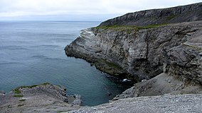
Burnt Cape Ecological Reserve
Appearance
| Burnt Cape Ecological Reserve | |
|---|---|
 Burnt Cape | |
 | |
| Location | Raleigh, Newfoundland and Labrador, Canada |
| Nearest city | St. John's |
| Coordinates | 51°34′23″N 55°44′45″W / 51.57306°N 55.74583°W |
| Area | 3.6 km2 (1.4 sq mi) |
| Governing body | Newfoundland and Labrador, Dept. of Environment and Conservation |
Location of Burnt Cape, Newfoundland
Burnt Cape Ecological Reserve is a nature reserve located within the town of Raleigh, Newfoundland and Labrador, and just northwest of Pistolet Bay Provincial Park. It has a large area of exposed limestone and a naturally harsh climate that permits the growth of rare dwarf flora often found in arctic and alpine areas.[1]
See also
[edit]References
[edit]- ^ Burnt Cape Ecological Reserve, Newfoundland and Labrador, Dept. of Environment and Conservation
External links
[edit]Wikimedia Commons has media related to Burnt Cape Ecological Reserve.
- Burnt Cape Ecological Reserve, Official web site
- List of flora, Botany Newfoundland and Labrador
- Burnt Cape Ecological Reserve, Official Brochure
- Photos of Burnt Cape Ecological Reserve

