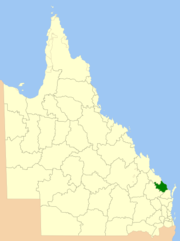
Bundaberg Region
| Bundaberg Region Queensland | |||||||||||||||
|---|---|---|---|---|---|---|---|---|---|---|---|---|---|---|---|
 Location within Queensland | |||||||||||||||
| Population | 99,215 (2021 census)[1] | ||||||||||||||
| • Density | 15.4276/km2 (39.957/sq mi) | ||||||||||||||
| Established | 2008 | ||||||||||||||
| Area | 6,431 km2 (2,483.0 sq mi)[2] | ||||||||||||||
| Mayor | Helen Blackburn | ||||||||||||||
| Council seat | Bundaberg | ||||||||||||||
| Region | Wide Bay–Burnett | ||||||||||||||
| State electorate(s) | |||||||||||||||
| Federal division(s) | |||||||||||||||
 | |||||||||||||||
| Website | Bundaberg Region | ||||||||||||||
| |||||||||||||||
The Bundaberg Region is a local government area in the Wide Bay–Burnett region of Queensland, Australia, about 360 kilometres (220 mi) north of Brisbane, the state capital. It is centred on the city of Bundaberg, and also contains a significant rural area surrounding the city. It was created in 2008 from a merger of the City of Bundaberg with the Shires of Burnett, Isis and Kolan.
The Bundaberg Regional Council, which administers the Region, has an estimated operating budget of A$89 million.
In the 2021 census, the Bundaberg Region had a population of 99,215 people.[1]
History
[edit]Prior to the 2008 amalgamation, the Bundaberg Region existed as four distinct local government areas:
- the City of Bundaberg;
- the Shire of Burnett;
- the Shire of Isis;
- and the Shire of Kolan.
Local government in the Bundaberg area began on 11 November 1879 with the creation of 74 divisions around Queensland under the Divisional Boards Act 1879. These included the Barolin, Burrum and Kolan divisions.[3][4]
The first eight years saw several areas break away and become self-governing due to increases in local population. The first was Bundaberg itself, which with an area of 4.1 square kilometres (1.6 sq mi) and a population of 1,192, split from Barolin on 22 April 1881 to form the Municipality of Bundaberg under the Local Government Act 1878. Areas to the south (Woongarra) and north (Gooburrum) of the Burnett River split from Kolan on 31 December 1885, and Barolin on 30 January 1886 respectively, while on 1 January 1887, the Isis Division further to the south split away from Burrum.[5] Thus by 1887, the Municipality of Bundaberg and the Barolin, Gooburrum, Isis, Kolan and Woongarra Divisions covered the entire territory of what is now the Bundaberg Region.
On 31 March 1903, after the passage of the Local Authorities Act 1902, the Municipality became a Town while the Divisions became Shires. On 22 November 1913, Bundaberg was proclaimed a City.[6]
On 21 December 1917, the Shire of Barolin was abolished and its area split between the City of Bundaberg and the Shire of Woongarra.[7] Bundaberg grew to 45.2 square kilometres (17.5 sq mi) and was united with what was then its entire suburban extent.
On 21 November 1991, the Electoral and Administrative Review Commission, created two years earlier, produced its second report, and recommended that local government boundaries in the Bundaberg area be rationalised. The Local Government (Bundaberg and Burnett) Regulation 1993 was gazetted on 17 December 1993, and on 30 March 1994, the Shires of Gooburrum and Woongarra were abolished, with most transferred into a new Shire of Burnett. A portion of Woongarra was transferred to the City, more than doubling its area and increasing its population by 8,200 in 1991 census terms.
On 15 March 2008, under the Local Government (Reform Implementation) Act 2007 passed by the Parliament of Queensland on 10 August 2007, the City of Bundaberg merged with the Shires of Burnett, Isis and Kolan to form the Bundaberg Region.[8]
Divisions and councillors
[edit]Although the Commission recommended the council be undivided with ten councillors and a mayor, the gazetted form was that of 10 divisions each electing a single councillor, plus a mayor representing the whole region.
Those elected at the 2024 local government election were:[9]
- Mayor: Helen Blackburn
- Division 1 Councillor: Jason Bartels
- Division 2 Councillor: Bill Trevor OAM
- Division 3 Councillor: Deb Keslake
- Division 4 Councillor: Tracey McPhee
- Division 5 Councillor: Larine Statham-Blair
- Division 6 Councillor: Carmen McEneany
- Division 7 Councillor: Gary Kirk
- Division 8 Councillor: Steve Cooper
- Division 9 Councillor: May Mitchell
- Division 10 Councillor: John Learmonth
Mayors
[edit]| Term start | Term end | Mayor | Notes |
|---|---|---|---|
| 2008 | May 2012 | Lorraine Pyefinch | [10] |
| May 2012 | March 2016 | Malcolm Foreman | [11] |
| March 2016 | March 2024 | Jack Dempsey | [12][13] |
| March 2024 | current | Helen Blackburn | [14] |
Suburbs
[edit]The Bundaberg Region includes the following settlements:
Outer Bundaberg-Burnett area: |
Kolan area:
North and West Burnett area: |
Isis area:
Other Burnett area:
|
1 – split with Gladstone Region
Demographics
[edit]The populations given relate to the component entities prior to 2008.
| Year | Population (Region total) |
Population (Bundaberg) |
Population (Gooburrum) |
Population (Woongarra) |
Population (Isis) |
Population (Kolan) |
|---|---|---|---|---|---|---|
| 1921 | 20,731 | 9,276 | 2,922 | 2,513 | 3,500 | 2,520 |
| 1933 | 25,387 | 11,466 | 3,915 | 3,287 | 3,778 | 2,941 |
| 1947 | 29,237 | 15,926 | 3,825 | 3,345 | 3,639 | 2,502 |
| 1954 | 34,531 | 19,951 | 4,131 | 3,704 | 4,243 | 2,502 |
| 1961 | 37,968 | 22,839 | 4,372 | 4,149 | 3,951 | 2,657 |
| 1966 | 41,444 | 25,402 | 4,776 | 4,934 | 3,718 | 2,614 |
| 1971 | 43,332 | 27,324 | 4,519 | 5,150 | 3,666 | 2,673 |
| 1976 | 51,084 | 30,456 | 5,227 | 8,791 | 3,926 | 2,684 |
| 1981 | 52,444 | 30,937 | 5,261 | 9,865 | 4,023 | 2,358 |
| 1986 | 55,990 | 31,427 | 5,917 | 11,915 | 4,082 | 2,649 |
| 1991 | 64,188 | 32,737* | 7,117 | 16,491 | 4,825 | 3,018 |
| 1996 | 73,846 | 42,554 | 21,218 | 5,878 | 4,196 | |
| 2001 | 77,323 | 43,146 | 23,598 | 6,045 | 4,534 | |
| 2006 | 84,434 | 45,901 | 27,232 | 6,663 | 4,638 | |
| 2011 | 89,810 | [16] | ||||
| 2016 | 93,897 | [17] | ||||
| 2021 | 99,215 | [1] | ||||
* The population of the 1996 area of Bundaberg in 1991 was 41,219.
Libraries
[edit]The Bundaberg Regional Council operate public libraries in Bundaberg Central, Childers, Gin Gin, and Woodgate Beach.[18]
References
[edit]- ^ a b c Australian Bureau of Statistics (28 June 2022). "Bundaberg Region (LGA)". 2021 Census QuickStats. Retrieved 28 February 2023.
- ^ "3218.0 – Regional Population Growth, Australia, 2017-18: Population Estimates by Local Government Area (ASGS 2018), 2017 to 2018". Australian Bureau of Statistics. Australian Bureau of Statistics. 27 March 2019. Archived from the original on 27 March 2019. Retrieved 25 October 2019. Estimated resident population, 30 June 2018.
- ^ "Agency ID 317, Barolin Divisional Board". Queensland State Archives. Retrieved 12 September 2013.
- ^ "Agency ID 547, Burrum Divisional Board". Queensland State Archives. Retrieved 12 September 2013.
- ^ Queensland Government Gazette, various issues. Accessed at Battye Library, Perth.
- ^ Queensland Government Gazette, Vol. CL, 22 November 1913, p.1422.
- ^ Queensland Archives. "Agency Details – Barolin Shire Council". Archived from the original on 5 April 2011. Retrieved 13 June 2011.
- ^ Queensland Local Government Reform Commission (July 2007). Report of the Local Government Reform Commission (PDF). Vol. 2. pp. 51–56. ISBN 978-1-921057-11-3. Archived (PDF) from the original on 7 April 2011. Retrieved 11 June 2011.
- ^ "2024 Local Government Elections: Saturday, 16 March 2024". Electoral Commission of Queensland. Retrieved 12 October 2024.
- ^ "2008 Bundaberg Regional Council - Mayoral Election - Election Summary". Electoral Commission of Queensland. 31 August 2010. Archived from the original on 29 March 2016. Retrieved 31 May 2016.
- ^ "2012 Bundaberg Regional Council - Mayoral Election - Election Summary". Electoral Commission of Queensland. 28 May 2012. Archived from the original on 8 May 2016. Retrieved 31 May 2016.
- ^ "2016 Bundaberg Regional Council - Mayoral Election - Election Summary". Electoral Commission of Queensland. 19 April 2016. Archived from the original on 25 May 2016. Retrieved 31 May 2016.
- ^ "2020 Local Government Elections: Saturday, 28 March 2020". Electoral Commission of Queensland. 2020. Retrieved 16 June 2020.[dead link]
- ^ "Election Results - Bundaberg Mayor". Electoral Commission of Qld. Retrieved 22 April 2024.
- ^ Queensland Government (30 May 2007). "Bundaberg, Bargara and Burnett Heads Defined Urban Area" (PDF). Archived from the original (PDF) on 29 March 2011. Retrieved 15 June 2011.
- ^ Australian Bureau of Statistics (31 October 2012). "Bundaberg Region (LGA)". 2011 Census QuickStats. Retrieved 21 June 2024.
- ^ Australian Bureau of Statistics (27 June 2017). "Bundaberg Region (LGA)". 2016 Census QuickStats. Retrieved 20 October 2018.
- ^ "Locations & Hours". Bundaberg Regional Council. Archived from the original on 30 January 2018. Retrieved 31 January 2018.
