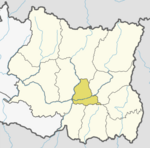
Budi Morang
Appearance
Budi Morang
बुढी मोरङ | |
|---|---|
| Coordinates: 26°55′N 87°20′E / 26.91°N 87.34°E | |
| Country | |
| Zone | Kosi Zone |
| District | Dhankuta District |
| Population (1991) | |
• Total | 3,602 |
| Time zone | UTC+5:45 (Nepal Time) |
Budi Morang is a village development committee in Dhankuta District in the Kosi Zone of eastern Nepal. At the time of the 1991 Nepal census it had a population of 3602 people living in 706 individual households.[1]
Climate
[edit]| Climate data for Budi Morang (Mul Ghat), elevation 365 m (1,198 ft) | |||||||||||||
|---|---|---|---|---|---|---|---|---|---|---|---|---|---|
| Month | Jan | Feb | Mar | Apr | May | Jun | Jul | Aug | Sep | Oct | Nov | Dec | Year |
| Mean daily maximum °C (°F) | 22.1 (71.8) |
24.9 (76.8) |
30.1 (86.2) |
33.5 (92.3) |
33.2 (91.8) |
33.1 (91.6) |
31.6 (88.9) |
31.5 (88.7) |
31.1 (88.0) |
30.5 (86.9) |
27.4 (81.3) |
23.3 (73.9) |
29.4 (84.9) |
| Mean daily minimum °C (°F) | 9.7 (49.5) |
10.9 (51.6) |
15.0 (59.0) |
19.0 (66.2) |
21.7 (71.1) |
24.0 (75.2) |
24.1 (75.4) |
23.9 (75.0) |
22.8 (73.0) |
20.1 (68.2) |
14.2 (57.6) |
10.0 (50.0) |
18.0 (64.3) |
| Average precipitation mm (inches) | 10.5 (0.41) |
12.8 (0.50) |
24.6 (0.97) |
48.3 (1.90) |
114.5 (4.51) |
178.4 (7.02) |
295.2 (11.62) |
191.7 (7.55) |
137.0 (5.39) |
51.2 (2.02) |
10.6 (0.42) |
6.3 (0.25) |
1,081.1 (42.56) |
| Source 1: Australian National University[2] | |||||||||||||
| Source 2: Japan International Cooperation Agency (precipitation)[3] | |||||||||||||
References
[edit]- ^ "Nepal Census 2001". Nepal's Village Development Committees. Digital Himalaya. Archived from the original on 12 October 2008. Retrieved 24 November 2008.
- ^ "CLIMATES OF NEPAL AND THEIR IMPLICATIONS FOR AGRICULTURAL DEVELOPMENT" (PDF). Australian National University. Archived from the original (PDF) on 23 October 2023. Retrieved 6 June 2024.
- ^ "ネパール国 全国貯水式水力発電所マスタープラン調査 ファイナルレポート" (PDF). Japan International Cooperation Agency. Archived from the original (PDF) on 6 April 2024. Retrieved 6 June 2024.


