Btourram

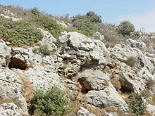
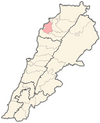
Btourram (Arabic, بطرام), also spelled Bterram, Bturan, or Beturan is a village in Koura District of Lebanon. The population is Greek Orthodox and other confessions.[1] In 1953, Bterram had a population of 739 living in 75 households.[2]
Etymology
[edit]
The known meanings of Btourram are the following:
- in Arabic "wind of the rock" or the rocky wind.
- "bet" "tur" "ram" means "House of the High Mountain".
- “beth” “turan” means “the temple” of “Turan” or Astarte (Phoenician/Canaanite Goddess).[3]
Local authorities
[edit]The municipal council is formed of 12 members headed by Dr. Haytham Serhan. Board members are Mikhael Salem, Elias Malek, John Serhan, George Sarkis, Marcelle Alagha, Ghada Salem, Henri Deeb, Ziad Yazbeck, Assaad Saoud, Souhail Serhan and George Malek. The mukhtar (mayors) are Khalil Salem and Michel Deeb.
Family and education
[edit]Bterram's family names are: Abboud, Alagha, Deab, Fellah, Jabbour, Jarjoura, Kalash, Khawli, Khoury, Makhoul, Mushahwar, Malek, Melki, Naser, Salem Saker, Sarkis, Serhan, Sha, Srour, Tannous, Yazbek, Younes...
Some of the most influential people are: Charles Malik, a philosopher and diplomat who was a leading figure in the drafting and adoption of the 1948 Universal Declaration of Human Rights and Elie Salem who held many influential political and academic positions and was the president of the Balamand University. Btourram has three schools: Khalil Salem High School headed by principal Michel Nasr, Khalil Salem Middle School and Universal School of Lebanon.
Archeology
[edit]
In archeology, Btourram is known for its middle palaeolithic site of Keoue [4] and an old underground sanctuary called Eshmunit.[5] Btourram also has one church dedicated to Cosmas and Damian and one monastery dedicated to Virgin Mary. Both date from the Crusades era.
References
[edit]- ^ "Municipal and ikhtiyariah elections in Northern Lebanon" (PDF). The Monthly. March 2010. p. 22. Archived from the original on 3 June 2016. Retrieved 30 October 2016.
{{cite web}}: CS1 maint: bot: original URL status unknown (link) - ^ Sawaya, Salah Michel (March 1953). Household Income and Expenditure in Al-Kura, Lebanon (PDF). Scholarworks (M.A.). Beirut, Lebanon: Economics Dept., American University of Beirut, Lebanon. hdl:10938/3411. Archived from the original (PDF) on 24 March 2023. Retrieved 2023-03-24.
- ^ "Bterram a Beautiful Village of Lebanon - History Section". Archived from the original on 2015-01-10. Retrieved 2012-05-25.
- ^ "Bterram Keoue Prehistoric Site: home". keoue.bterram.com.
- ^ "Bterram Phoenician Sanctuary: Eshmunit home". eshmunit.bterram.com. Archived from the original on 2020-10-24. Retrieved 2023-01-07.
External links
[edit]- Bterram, Localiban
- Bterram a Beautiful Village of Lebanon - Homepage Archived 2014-09-04 at the Wayback Machine official site

