Brighthampton
| Brighthampton | |
|---|---|
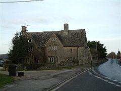
 Manor Farmhouse, Brighthampton | |
Location within Oxfordshire | |
| OS grid reference | SP3803 |
| Civil parish | |
| District | |
| Shire county | |
| Region | |
| Country | England |
| Sovereign state | United Kingdom |
| Post town | Witney |
| Postcode district | OX29 |
| Dialling code | 01865 |
| Police | Thames Valley |
| Fire | Oxfordshire |
| Ambulance | South Central |
| UK Parliament | |
| Website | Welcome to Standlake Oxfordshire |
Brighthampton is a hamlet which is contiguous with the village of Standlake, about 4 miles (6.4 km) south of Witney, in West Oxfordshire, in the county of Oxfordshire, England.
Archaeology
[edit]A large pagan burial ground from the 5th and 6th centuries has been found south of Malthouse Farm in Brighthampton.[1] It was revealed when ploughing disturbed human bones in 1820. Excavation in 1857–58 found 54 burials, 10 cremation burials and a wide range grave goods, which are now in the Ashmolean Museum in Oxford.[2] Notable artefacts found include an iron sword with a gilt scabbard and an ornate gilt brooch.[3] Since then set of six burials was found at Malthouse Farm in 1892,[3] and the burial of a child was found in 1949.[4]
History
[edit]Brighthampton's toponym means Beorhthelm's tūn.[1] In the 10th century it was part of the royal manor of Bampton, and in 984 Æthelred II gave land at Brighthampton to one of his ministers.[5] The Domesday Book records that in 1086 William the Conqueror's half-brother Odo, Bishop of Bayeux was Brighthampton's feudal overlord.[5] However, William I imprisoned Odo from 1082 until 1087 and confiscated his lands. In 1131 Henry I granted land at Brighthampton to Sées Priory in Normandy.[5] This is likely to have been the same land that William I had confiscated from Odo.[5] At the same time Henry granted land at Hardwick to the same priory, and these together became a single manor of Hardwick and Brighthampton.[5] There is a record from early in the 17th century of Brighthampton having a stone cross, and in 1857 it was recorded that there was still the base of an "ancient" stone cross (presumably medieval) at the hamlet's central crossroads.[1]
In 1931 the civil parish had a population of 33.[6] On 1 April 1932 the parish was abolished and merged with Standlake.[7]
Historic buildings
[edit]Forge Cottage is a 16th-century timber-framed building supported by a central cruck.[1] By 1776 it was trading as a public house, the Red Lion.[1] Another pub in Brighthampton, the Golden Balls, had been licensed by 1753.[1] It was rebuilt early in the 20th century, ceased trading in 1992 and was demolished in 1994.[1] The farmhouse of Manor Farm (also called Florey's Farm) is of Cotswold stone and was built early in the 17th century.[1] It was extended in the middle of the 17th century and again in the 19th century.[1]
Baptist chapel
[edit]A few families of nonconformists were recorded in the parish in the latter part of the 17th century, and in the 18th century several local families were Anabaptists who attended a chapel in Cote.[8] A Baptist chapel was built between Brighthampton and Standlake in 1832, flourished in the 1840s and 50's and a gallery was added to increase capacity in 1865.[8] In the 20th century falling attendances led to services being discontinued in 1937, but they were resumed in 1951.[8] The chapel finally closed in 1978 and in 1994 it was serving as the offices of a missionary society.[8] It is now a private house.[9]
References
[edit]- ^ a b c d e f g h i Crossley & Currie 1996, pp. 171–180
- ^ "Brighthampton Anglo-Saxon Cemetery: Finds from Various Graves". Anglo-Saxon Oxfordshire. Ashmolean Museum. 22 December 2005. Retrieved 14 December 2013.
- ^ a b "The Anglo-Saxon Cemetery at Brighthampton". Anglo-Saxon Oxfordshire. Ashmolean Museum. 22 December 2005. Retrieved 14 December 2013.
- ^ Atkinson & Kirk 1949, p. 75.
- ^ a b c d e Crossley & Currie 1996, pp. 180–183
- ^ "Population statistics Brighthampton CP/Hmlt through time". A Vision of Britain through Time. Retrieved 5 April 2024.
- ^ "Witney Registration District". UKBMD. Retrieved 5 April 2024.
- ^ a b c d Crossley & Currie 1996, pp. 203–204
- ^ Oxfordshire Churches & Chapels: Standlake Archived 21 February 2015 at the Wayback Machine
Sources and further reading
[edit]- Atkinson, R.J.C.; Kirk, J.R. (1949). "Archaeological Notes 1949" (PDF). Oxoniensia. XIV. Oxford Architectural and Historical Society: 75. ISSN 0308-5562.
- Baggs, A.P.; Chance, Eleanor; Colvin, Christina; Day, C.J.; Selwyn, Nesta; Townley, Simon C. (1996). "Standlake". In Crossley, Alan; Currie, C.R.J. (eds.). A History of the County of Oxford. Victoria County History. Vol. 13: Bampton Hundred (Part One). pp. 171–180. ISBN 978-0-19722-790-9.
- Ford, Steve; Preston, Steve (2002). "Medieval Occupation at The Orchard, Brighthampton" (PDF). Oxoniensia. LXVII. Oxfordshire Architectural and Historical Society: 287–312. ISSN 0308-5562.


