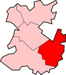
Bridgnorth District
| Bridgnorth District | |
|---|---|
 Council Offices, Westgate, Bridgnorth | |
 Shown within Shropshire non-metropolitan county | |
| History | |
| • Origin | Bridgnorth Rural District Much Wenlock Municipal Borough Shifnal Rural District (part) |
| • Created | 1 April 1974 |
| • Abolished | 31 March 2009 |
| • Succeeded by | Shropshire |
| Status | District |
| ONS code | 39UB |
| Government | Bridgnorth District Council |
| • HQ | Bridgnorth |
Bridgnorth District was a local government district in Shropshire, England, from 1974 to 2009. Its council was based in the town of Bridgnorth. The district also included the towns of Much Wenlock, Shifnal and Broseley and the villages of Albrighton and Sheriffhales, as well as RAF Cosford.
History
[edit]The district was formed on 1 April 1974, under the Local Government Act 1972. The district covered the former Bridgnorth Rural District, and nearly all of the Shifnal Rural District, excluding a small part of Shifnal parish within the area of Telford New Town, which went to Wrekin district.[1] The former municipal boroughs of Much Wenlock and Bridgnorth had been converted into rural boroughs in 1966 and 1967 respectively, making them part of Bridgnorth Rural District whilst retaining some of their civic dignities such as the right to appoint a mayor.[2]
The new district created in 1974 was administered by Bridgnorth District Council until abolition on 31 March 2009. From 1 April 2009 the area was administered by the new Shropshire unitary authority created as part of the 2009 structural changes to local government in England.
Energy policy
[edit]In May 2006, a report commissioned by British Gas [1] showed that housing in the district of Bridgnorth produced the 12th highest average carbon emissions in the country at 7,176 kg of carbon dioxide per dwelling.
Political control
[edit]The first elections to the council were held in 1973, initially operating as a shadow authority until coming into its powers on 1 April 1974. Political control of the council from 1974 until its abolition in 2009 was held by the following parties:[3]
| Party in control | Years | |
|---|---|---|
| Independent | 1973–2003 | |
| No overall control | 2003–2009 | |
Leadership
[edit]The last leader of the council was Elizabeth Yeomans, an independent.
| Councillor | Party | From | To | |
|---|---|---|---|---|
| Elizabeth Yeomans[4] | Independent | 31 Mar 2009 | ||
Elections
[edit]- 1973 Bridgnorth District Council election
- 1976 Bridgnorth District Council election
- 1979 Bridgnorth District Council election (New ward boundaries)[5]
- 1983 Bridgnorth District Council election
- 1987 Bridgnorth District Council election
- 1991 Bridgnorth District Council election (District boundary changes took place but the number of seats remained the same)[6]
- 1995 Bridgnorth District Council election
- 1999 Bridgnorth District Council election
- 2003 Bridgnorth District Council election (New ward boundaries)[7]
- 2007 Bridgnorth District Council election
By-election results
[edit]| Party | Candidate | Votes | % | ±% | |
|---|---|---|---|---|---|
| Liberal Democrats | 126 | 51.9 | +5.0 | ||
| Conservative | 117 | 48.2 | +48.2 | ||
| Majority | 9 | 3.7 | |||
| Turnout | 243 | 21.4 | |||
| Liberal Democrats gain from Independent | Swing | ||||
| Party | Candidate | Votes | % | ±% | |
|---|---|---|---|---|---|
| Conservative | 171 | 60.4 | +60.4 | ||
| Independent | 112 | 39.6 | −16.6 | ||
| Majority | 59 | 20.8 | |||
| Turnout | 283 | 14.0 | |||
| Conservative gain from Independent | Swing | ||||
| Party | Candidate | Votes | % | ±% | |
|---|---|---|---|---|---|
| Conservative | 295 | 62.5 | +11.9 | ||
| Liberal Democrats | 177 | 37.5 | +37.5 | ||
| Majority | 118 | 25.0 | |||
| Turnout | 472 | 36.0 | |||
| Conservative hold | Swing | ||||
References
[edit]- ^ "The English Non-metropolitan Districts (Definition) Order 1972", legislation.gov.uk, The National Archives, SI 1972/2039, retrieved 18 September 2022
- ^ "Bridgnorth Rural District". A Vision of Britain through Time. GB Historical GIS / University of Portsmouth. Retrieved 18 September 2022.
- ^ "Compositions calculator". The Elections Centre. Retrieved 10 August 2022.
- ^ "Delight as relief road opens". Shropshire Star. 9 March 2009. Retrieved 18 September 2022.
- ^ The District of Bridgnorth (Electoral Arrangements) Order 1976
- ^ legislation.gov.uk - The Hereford and Worcester and Shropshire (County Boundaries) Order 1991. Retrieved on 5 November 2015.
- ^ legislation.gov.uk - The District of Bridgnorth (Electoral Changes) Order 2000. Retrieved on 4 October 2015.
52°32′03″N 2°25′06″W / 52.53417°N 2.41833°W


