Brâncoveni
Appearance
Brâncoveni | |
|---|---|
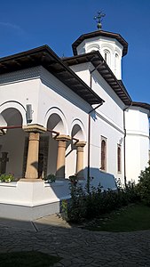
 Brâncoveni Monastery | |
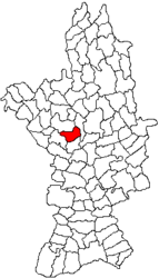
 Location in Olt County | |
| Coordinates: 44°19′N 24°18′E / 44.317°N 24.300°E | |
| Country | Romania |
| County | Olt |
| Government | |
| • Mayor (2020–2024) | Ion Cheroiu (PSD) |
Area | 39.7 km2 (15.3 sq mi) |
| Elevation | 126 m (413 ft) |
| Population (2021-12-01)[1] | 2,368 |
| • Density | 60/km2 (150/sq mi) |
| Time zone | EET/EEST (UTC+2/+3) |
| Postal code | 237050 |
| Vehicle reg. | OT |
| Website | www |
Brâncoveni is a commune in Olt County, Oltenia, Romania. It is composed of four villages: Brâncoveni, Mărgheni, Ociogi, and Văleni. It covers an area of 39.7 km2 (15.3 sq mi).[2]
Geography
[edit]The commune is situated in the Wallachian Plain, at an altitude of 126 m (413 ft). It lies on the right bank of the Olt River; the Oltișor flows through Ociogi village.
Brâncoveni is located in the central part of Olt County, 19 km (12 mi) south of the county seat, Slatina.[2] It is crossed by the national road DN64, which runs from Caracal, 25 km (16 mi) to the south, to Râmnicu Vâlcea, 95 km (59 mi) to the north.
Natives
[edit]- Matei Basarab (1588–1654), Prince of Wallachia between 1632 and 1654
- Constantin Brâncoveanu (1654–1714), Prince of Wallachia between 1688 and 1714
References
[edit]- ^ "Populaţia rezidentă după grupa de vârstă, pe județe și municipii, orașe, comune, la 1 decembrie 2021" (XLS). National Institute of Statistics.
- ^ a b "Localizare pe hartă". www.primariabrancoveni.ro. Brâncoveni townhall. Retrieved August 16, 2023.


